
THE FOLLOWING IS A PRELIMINARY WINTER WEATHER OUTLOOK BY UPSTATE SNOW. THIS COULD CHANGE IN THE NEXT 15, 30 AND/OR 45 DAYS. THE FINAL OUTLOOK IS ISSUED ON DECEMBER 1 EVERY YEAR.
We normally start on November 1st. But social media is driving this train now. More and more every year. Forecasts and outlooks for the upcoming winter become sooner and sooner. And when things are going like they are going right now, you have the feeling you have something to play with for November, December and the upcoming winter season. Seriously. So we will launch the WINTER WEATHER OUTLOOK NOW! We will have our usual updates on November 1 and November 15 like usual, but the updates will probably be shorter.

THE BOTTOM LINE
Will it be a top 10 winter out of the last 130 years? Probably not. Top 25? Definitely a much bigger possibility! The chances for Upstate NY to have a good winter season are higher than normal this year than other years. Particularly of the last several years. With the exception of last winter, you have to go back to 2018-19 for a “normal” to “above normal” winter. From 2013-14 to 2018-19, five out of those six winters were anywhere from decent to awesome. Since 2018-19, as we have been back here on this Upstate Snow page, the numbers have gone up considerably. The snowfall amounts? Nope! In fact some of the top 10 lowest snowfall totals happened in the last few years. Take 2023-24 for example. Who wants to see 47″ of snow for a season with over 1/3 of it in the SPRING??? Nope. Not us!
IT SNOWED LAST WINTER ALREADY! IT HAS NOT SNOWED YET HERE! WHAT ARE YOU TALKING ABOUT WITH A BIGGER THAN NORMAL WINTER?
Well let’s talk about the fall and winter of 2024-25, shall we? It started with a HUGE cold blast in the middle of the month. Like literally right now! The 14th, 15th and 16th of October we had cold enough temperatures for rain to fall as snow over many parts of Northern NY. In the higher elevations, it was more than enough for accumulation and ground coverage! It gave us some of our best stats of the year! Then, it stopped and went away. For a long time. By the end of October, it was up near a record high of almost 80 degrees! These near record temperatures for so late in the year lasted through the first week of November too. And I said it then because I saw a 2003/04 vibe to that year. Later November and into December it did snow somewhat, but it was way below normal. Christmas was green. Again. And by New Year’s Day it was green. Again. But something was up with very warm Lake Ontario about to get hit with a huge blast of lake effect snow. It had been 18 years, since 2007, that Central New York saw a lake effect event this big. It was our generational snowfall event. January 1-5 totally turned the winter around! Suddenly there was snow everywhere! And in some areas, there was TONS OF IT! People started getting out and playing in it!
We came up to ride in mid January on the 15th for the first time in 3 years. It was an amazing 125 mile riding day, which got knocked out by the glassy conditions of the first 75 miles getting bumped and lumped in by the last 50 miles. We were dead after that ride we were not expecting. We got out of Central NY just before another snowstorm hit the area. And another after that. Then another. And another. Then in mid-February, yet a second generational snowstorm hit many of the same areas. This caused the unthinkable: Total roof collapses. Most of these roofs were in Oswego, Oneida, Lewis, Herkimer and Madison Counties with other areas hit not as bad. The snows kept piling up. It was not record snow, but it was close to it for parts of Upstate NY, especially downwind of Lake Ontario. People who had little snow at the end of December had between 100-300 inches of it in two months! No wonder why so many roofs collapsed! Damage is still being repaired to some of these structures to this day. Some may never get rebuilt.
March came. So did the lion. And it roared loudly! With warmth and rain. Tons of rain! This led to a major weigh down of the snow and flooding across parts of Upstate NY. Thankfully despite the fact there was so much snow, because nearly all of it came because of lake effect, the water content within the snow was not as high as it could have been. Thank God! Within a few weeks, all that snow and water was GONE. The last 7 months we have been sitting here waiting for this.
SO WHERE ARE WE RIGHT NOW?
We are above normal on temperatures (go figure), below normal on precipitation (in a drought, go figure), and zero snow so far. Go figure on it all! Will it stay like this forever? NOPE!
Have we had frosty mornings lately? YES! Will there be another one tonight? YES. It will be in the 20s when you wake up Friday morning the 17th of October. It will be milder for the upcoming weekend. We are back to 70 by Sunday. Then another few rounds of showers have to go through here both early next week and middle of next week.
COLDER AIR COMING ON IN
Later next week and into the last weekend of October, about 6-10 days away, temperatures will dive to near normal if not go below normal for a few days. While this possibility is looking more likely for the Ohio Valley and the Mid Atlantic, it’s looking more like “normal” for Upstate NY. Which remember now, at the end of October, means a high in the low to mid 50s, with lows not too far from freezing each night.
WARMING BACK UP BY HALLOWEEN AND INTO EARLY NOVEMBER
The outlook is for this colder pattern to be a temporary thing with temperatures having a good shot at the above normal standing with highs in the 50s to 60s and lows in the 30s and 40s. This is based on both the 8-14 day outlooks issued today on 10-16-25 and the 3-4 week outlook issued last week. That should take us through the first week of November.
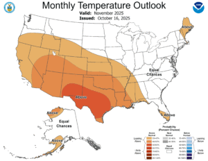
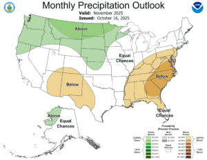
NOVEMBER 2025 OUTLOOK
Normal temperature. Normal precipitation. There are hints the precipitation may not be as much. Remember the golden rule: When in drought, leave it out! That’s where we are now with the worst drought in 18 years over us. But with cooler air, more cloudy, damp, and wetter conditions moving in, this drought should begin to ease. It will not end in the month of November, if anything, probably not until the first quarter of 2026. And if our forecast holds, it will be a big part of the reason for that. Because:
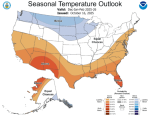

THE SEASONAL OUTLOOK IS NORMAL. IF ANYTHING WE ARE CLOSE TO ABOVE NORMAL SNOW WITH BELOW NORMAL TEMPS
We are not there. Yet. Trust me we are not there. This map is very basic for going into a weak La Nina pattern, which is what we are expecting, then deteriorating over the winter, at some point, into LA NADA. What is that??? It’s a point to which there is NO EL NINO AND NO LA NINA. It’s a point to where sea surface temperatures over the Pacific Ocean, specifically where these numbers are measured, come out between 0.5 degrees C above or below normal. Or within one degree F of NORMAL. So if we can hold NORMAL, this pattern could get wavy. The heavy lake effect snows being indicated to the west of Upstate NY could swing heavily into Western NY. Or if it makes it into Lake Ontario, Central and Northern NY. In addition, the storm track is variable, and it comes straight up the Appalachians. If the storms go west, we go snow to mix to rain (possibly) then back to snow. If these storms track east of the Appalachians, then it’s GAME ON! WE ARE PLAYING HARDBALL THEN! With Nor’easters followed by Lake Effect snow, the totals could add up QUICK!
WHAT ARE THE X-FACTORS?
When? When do these storm opportunities hit? Do they hit at the right times? Do they hit too early? Too late? Will early to mid March continue to be the early “end of winter” and the dud time for snowmobiling with conditions barely rideable with heavy late March and April snowfalls?
PRELIMINARY FORECAST FOR 2025-26 WINTER
SNOWFALL – 90 to 120 INCHES (near to above normal)
TEMPERATURE – NEAR NORMAL (Within 3 degrees of NORMAL)
*- THESE FIGURES ARE BASED ON GRIFFISS AIRFIELD IN ROME, NY
LOCATIONS ELSEWHERE IN NEW YORK STATE WILL VARY WITH ELEVATION AND TERRAIN
If you have read this far: THANK YOU FOR DOING SO!
If you would like to sponsor this site this season, here is how you do it:
$15
For 15 dollars, less than the cost to join your club, you can become a PERSONAL MEMBER of Upstate Snow!
You will get a return note with a THANK YOU from us along with one Upstate Snow sticker! You will also receive your name on our growing list of people and businesses. Yours will be at the bottom of the page.
$75
For $75 dollars, you can become a BUSINESS MEMBER of Upstate Snow! You will get not just a return THANK YOU but FIVE Upstate Snow stickers! Your business name will appear on our list of growing businesses along with the link to the website of your choice. Yours will appear above the personal members.
$250
For $250 dollars, you can become a BUSINESS SPONSOR of Upstate Snow! You get a 200 X 200 banner ad on the site which lasts until September 30, 2026. You also get 16 Upstate Snow stickers, and first line recognition on everything our site does in the next year.
$500
For $500 dollars, you can become a BUSINESS CHAMPION of Upstate Snow! You get a 200 X 800 banner ad on the site which lasts until September 30, 2026. You also get 32 Upstate Snow stickers, and top line recognition on everything our site does every year above everyone and everything else. You are the first sponsor mentioned all the time.
HERE IS HOW YOU PAY US:
VENMO: @Zman291
CASH APP: #ZACKLUPIA
Zack and Rich Lupia
Upstate Snow
October 16, 2025
Please thank our advertisers on Upstate Snow!
Business Sponsorship
Ohio Ridge Riders
Enjem’s Flooring America
ilsnow.com
Saratoga Snowmobile Association
Southern Tug Hill Snow-Riders
Business Member
John Schoff Polaris Memorial Ride
Personal Member
Charles A. Klesse Sr.


