
THERE IS TROUBLE COMING! IT STARTS THANKSGIVING DAY AND LAST THROUGH THANKSGIVING WEEKEND. THE WORST OF IT WILL BE ON BLACK FRIDAY. POTENTIALLY HEAVY LAKE EFFECT SNOWS. THIS IS NOT A DEFINITE FORECAST OF THIS YET, HOWEVER, THE ODDS OF THIS HAPPENING ARE INCREASING QUICKLY AND RAPIDLY!
Ok so there is a lot to get to for this Thanksgiving Week coming up. I think the best thing to do here is concentrate on this forecast one day at a time. Since that is how you are planning and/or executing your Thanksgiving Week holiday plans, this will help guide you the best. We start with tomorrow:

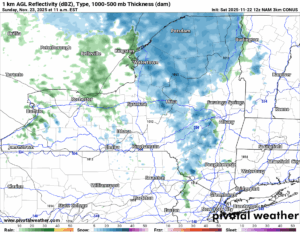
SUNDAY
A disturbance will move on through in the westerly flows and bring with it a period of snow showers. There will be a changeover to rain showers in the lower elevations. Look for a dusting to maybe an inch locally, especially in the higher elevations where temperatures may hang closer to freezing and melting will not be as big of a factor.
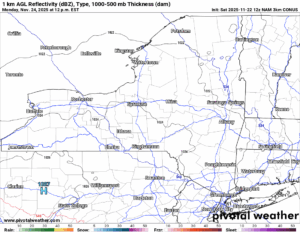
MONDAY
Sunshine returns across Upstate NY with this being not only a partly sunny day but the best day we have out of the next 7 days. Highs will range from the 30s higher up, to the 40s in the lower elevations.
TUESDAY
Clouds move in from west to east early in the day as our storm approaches the Great Lakes and the Northeast. It doesn’t make it by nearly sunset (4 PM – I KNOW!), but definitely count on showers for Tuesday Night at the least.
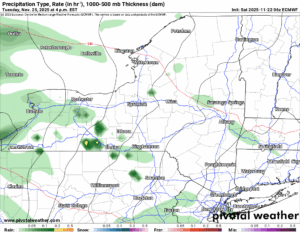
WEDNESDAY
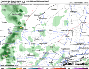
This by far will be the warmest day of the period. It will also turn breezy as our storm winds up over the Great Lakes and into Southern Canada. Expect temperatures to shoot through the 50s, even in the higher elevations. A few spots in Upstate NY on this day will top 60 degrees. Expect scattered showers with a brief period of steady rainfall. Then the cold front moves through Wednesday Night and things begin to change.
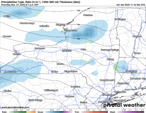
THANKSGIVING DAY
TURKEY! GOBBLE GOBBLE! And also, getting colder and colder! Temperatures will be holding steady if not falling during the day. Any rain that is left will change to snow. And, you guessed it, the lake effect machine is back! Buhahaha!
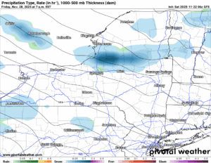
BLACK FRIDAY
This is the day I am looking forward to. NOT BECAUSE OF DEALS! BUT BECAUSE OF THE HEAVY SNOW THAT MANY IN UPSTATE NY WILL GET! We are at Day 6-7 at this time so we are in the range of chances going up, or are chances going down. At the moment, they are going up. You know the map I had showed a few days ago that had a coastal low and it was Day 8-9 and I said keep and eye on it? Well we did. It’s not happening. If anything, LAKE EFFECT BABY!!!
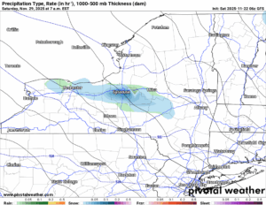
SATURDAY
The big college game day. The last regular season day for it. And we will see the lake effect snows taper off on this date. It will remain colder than normal with afternoon temperatures barely breaking freezing and overnight lows well below that.
BOTTOM LINE
We are studying closely the lake effect event coming up starting Thanksgiving Day, peaking on Black Friday, then ending on Saturday. It will be cold at the end of next week and through next weekend to finish November, but there will not be anything near record cold numbers to talk about. Just general below normal weather to end the month. Gobble Gobble!!!
Looking ahead into December we are seeing the most positive signs of cold and snow since 2018! Pray that the snow we get in the next week we can keep this time then add to it heading into Snowdeo and the opening of Northern NY trails in a few weeks!
If you would like to advertise on the site, reach out anytime!
VENMO: @Zman291
CASH APP: #ZACKLUPIA
Zack and Rich Lupia
Upstate Snow
November 22, 2025
Please thank our advertisers on Upstate Snow!
Business Sponsorships
Ohio Ridge Riders
Enjem’s Flooring America
ilsnow.com
Saratoga Snowmobile Association
Southern Tug Hill Snow-Riders
Business Members
John Schoff Polaris Memorial Ride
Personal Members
James Andre
Eric Vilovchik
Charles A. Klesse Sr.


