
HERE IS MY REVISED SNOWFALL FORECAST FOR THE UPCOMING THANKSGIVING DAY AND BLACK FRIDAY LAKE EFFECT SNOW EVENT. I KNOW IT’S CRAZY WITH TEMPERATURES IN THE 50S AND 60S WITH THUNDERSTORMS AROUND AS YOU ARE READING THIS. HOWEVER. THIS IS COMING. WE HAVE PROMISED THIS ALL ALONG. THERE ARE SOME CHANGES TO THIS AS OPPOSED TO YESTERDAY’S FORECAST THAT I WISH TO EXPLAIN:
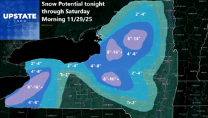
Yes I definitely wish to explain. Especially with this being the Thanksgiving and Black Friday rush all around everywhere to a lot of places many of us do not know and/or are not familiar with, what is going on here? I put out the snowfall map yesterday and it changed. Some areas went up. Some areas went down. Why? This was after study of the last several model runs and where I expect the most snow to happen. I expect the most snow to happen in the 250 to 270 wind direction. This means Buffalo, Watertown, and to the main parts of the Tug Hill and Adirondacks. Yes I did play with the Black River Valley on this one dropping accumulations here instead of leaving it in the 8-16. I could very well pay for that. We shall see. The lake effect bands will gradually work their way southward, turning W then WNW and finally more to the NW before settling for a time. That is where the second band of lake effect snows is set up south and east of Syracuse. And also pretty much from the City of Buffalo to Batavia and points south and west, count of getting BOMBED with 8 to 16 inches of snow at the least. Some locations could see 20-24 inches but I would consider that locally.

BOTTOM LINE
I am not going super high on the lake effect for two reasons here: 1) The bands will be constantly shifting. This means a lot more people across Upstate NY will see accumulating snows. But also, that means everyone will see less snow overall. 2) The strong winds: This will cause the bands to not have the staying power because the winds are stronger than normal, especially Thursday Night and Friday. This means a lot of blowing and drifting snow, but not as much serious accumulations.
Will this theory in my forecast work out? We are about to find out whether or not it will. Let’s go to the high resolution!
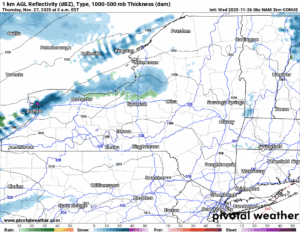
OVERNIGHT
As this sharply colder air blows on in, it is coming to us not from the northwest but actually from the west southwest to almost a southwest direction. The initial wind flow on the latest guidance is 240. That’s NORTH of Watertown and Buffalo. That’s Niagara County. Northern Jefferson and Northern St. Lawrence Counties near the Canadian Border. At least, this is where this band wants to start playing. So we will go along with their tune.
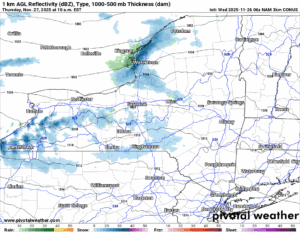
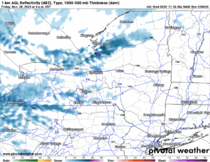
THANKSGIVING MORNING
The band has already rolled south through the City of Buffalo and is getting into the South Towns like Orchard Park. Off of Lake Ontario, the mess along the Canadian Border has settled southbound and is about to hit Watertown. Areas outside of these areas of Western and Northern NY are waking up to a mix of clouds and sun, windy conditions, and much colder temperatures. Those will stick around no matter whether it is snowing or not!
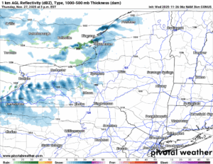
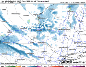
THANKSGIVING AFTERNOON
When you family is sitting to eat their Thanksgiving Dinner (GOBBLE GOBBLE), expect the snows to continue in the Watertown and Buffalo areas. Snows off of Lake Erie may extend quite a ways inland and produce even a dusting to an inch or two in places not normally used to lake effect. It’s that kind of a day here. Winds will gust over 40 MPH!
THURSDAY OVERNIGHT
A secondary cold front has raced on through Upstate NY and it did so quickly. This is continuing to move the winds from more of a westerly direction to a WNW direction. This is getting Utica/Rome and the Mohawk Valley into play with the heaviest snows. To the south of Lake Erie, Buffalo area and most of the suburbs are clear with just the exception of scattered snow showers, mainly in Chautauqua, Cattaraugus and Allegheny Counties.
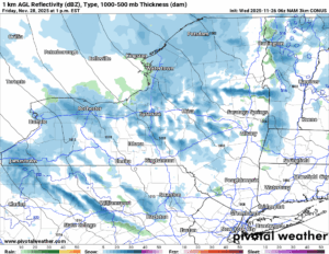
BLACK FRIDAY AM
The lake effect is continuing to hit the Utica/Rome area and the Mohawk Valley area hard, but over time, this will end as it sets up closer to Syracuse and areas to the south and east of Syracuse. The hills south and east of Syracuse, Utica and the Mohawk Valley you start to get your fill of the snow!
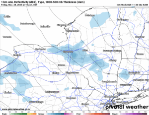
BLACK FRIDAY PM
The lake effect is settling down on a 300 to 315 wind direction. This means Syracuse and points south and east through the eastern Southern Tier and into the Catskills. The Binghamton area, especially west of there, should miss this event entirely, however, areas north and east of Binghamton will pick up on the snows quickly.
SATURDAY AM
The leftover lake effect snows are dying out over the same areas, going from occasionally heavy snow showers and squalls to lighter snow showers before it ends. Otherwise expect a partly sunny day to take over the rest of Upstate NY.
SNOWFALL ACCUMULATIONS
Here once again is the map. I always do my best to get these right. There is always somewhere I am too high or low on. Most of the time these maps are accurate and reliable. Of course you are only as good as your last sale!
NEXT STORM
This is the next storm expected to arrive on Sunday. There has continued to be variance on this, from what looked like a dead Warm Air Advection precipitation event. Which is simple for us Meteorologists. With this big lake effect event coming tonight, tomorrow and Friday, wait for Saturday for us to explain what exactly we should get Sunday and Sunday Night (Snow to Mix to Rain then back to a Mix or Snow). Basically. A MESS!
If you would like to advertise on the site, reach out anytime!
VENMO: @Zman291
CASH APP: #ZACKLUPIA
Zack and Rich Lupia
Upstate Snow
November 26, 2025
Please thank our advertisers on Upstate Snow!
Business Sponsorships
Ohio Ridge Riders
Enjem’s Flooring America
ilsnow.com
Saratoga Snowmobile Association
Southern Tug Hill Snow-Riders
Business Members
John Schoff Polaris Memorial Ride
Personal Members
James Andre
Eric Vilovchik
Charles A. Klesse Sr.


