
ARE YOU AREADY FOR DECEMBER? YOU HAD BETTER BE! IT IS LOOKING LIKE A CLASSIC GOOD OLD FASHIONED WINTER IS HERE AND WILL BE PRODUCING COLD AND SNOW PRETTY MUCH EVERY DAY FOR THE FORESEEABLE FUTURE. IN THE SHORT TERM. IN THE MEDIUM TERM. IN THE LONG RANGE. EVERYTHING IS POINTING TO THIS. WE START WITH TUESDAY:
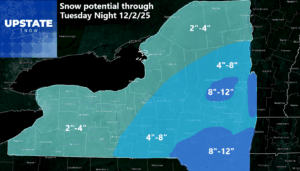
As you can see, this is the first general snowfall system for the 2025-26 season for Upstate NY. This is by no means a record breaker, but some areas could see some. Best chance of the heaviest snow is Central NY, Southern Adirondacks, the Capital Region, Hudson Valley, eastern Southern Tier and the Catskills. Locally over a foot of snow in the heaviest bands of snow are possible. Through the middle of the state from Binghamton and Elmira up through the Finger Lakes and the Syracuse area into the Central Adirondacks is the next tier with more of a 4-8 inch call. The 2-4 call goes to Western NY, along Lake Ontario and into the Northern Adirondacks and North Country. The snow is over Tuesday Night.

WEDNESDAY NIGHT INTO THURSDAY
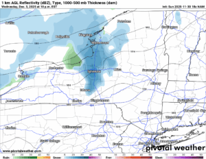
Looking farther out on the NAM to 84 hours, our next storm system is moving in overnight Wednesday and into Thursday morning with snow showers and areas of lake effect squalls. These will not be overly heavy or statewide, however those areas that do see it will see potentially another several inches of accumulation.
THIS WEEKEND
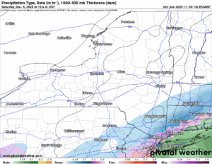
We are on the Euro now and moving into next weekend. In this case the Mid Atlantic seems to be the target for this winter storm. It does look like it will get into PA, NJ, the NYC area and into the lower Hudson Valley. It will be close to Upstate NY but not close enough to the areas we cover for concern. But we have several days to watch it.
THE EXTENDED – COLD EVERYWHERE!
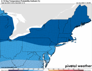
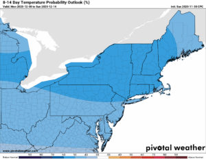
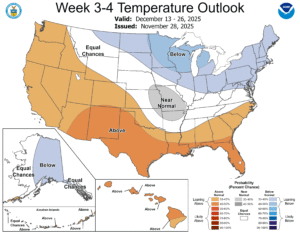
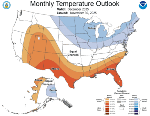
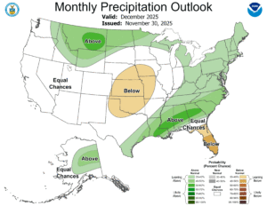
Everywhere you look, it is looking colder than normal for December. It is also looking wetter than normal with a very active storm track. I hate to say this, however, this may make it THE BUSIEST START FOR UPSTATE SNOW EVER! In my years of doing this since 2012, the closest I came to crazy cold and snow was 2013, 2017, and 2018. The rest of the years we have had big warm ups. One thing is for sure: You will NOT see a sunny and 60 degree day this month. At all. Or if you get really unlucky, you’ll see a big drop afterwards with big snows after that. Trust me. I have lived through this!
COMING TOMORROW – THE UPSTATE SNOW FINAL WINTER WEATHER OUTLOOK.
GEE. *YAWN*!
If you would like to advertise on the site, reach out anytime!
VENMO: @Zman291
CASH APP: #ZACKLUPIA
Zack and Rich Lupia
Upstate Snow
November 30, 2025
Please thank our advertisers on Upstate Snow!
Business Sponsorships
Ohio Ridge Riders
Enjem’s Flooring America
ilsnow.com
Saratoga Snowmobile Association
Southern Tug Hill Snow-Riders
Business Members
John Schoff Polaris Memorial Ride
Personal Members
James Andre
Eric Vilovchik
Charles A. Klesse Sr.


