
The Morning Blog is brought to you by the Turin Ridge Riders of Turin, NY. NOW OPEN! “Promoting Groomed Snowmobile Trails For All To Enjoy!” The Turin Ridge Riders have 38 miles of trails over some of the busiest trails in the east! No matter what you need, TRR has the snow for you! If it doesn’t you are probably not riding anywhere else! For more information CLICK HERE.
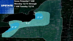
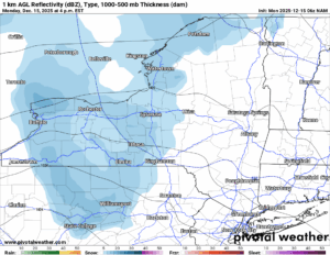
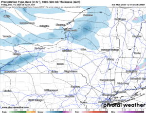
Hello! We have just a little bit more snow to go today and this evening. This clipper system that has been indicated by the models all along has gotten progressively weaker each run to where by the time it is getting to showtime, today, it is but a whimper. A dusting to an inch or two is possible. A few more inches in the Tug Hill and also in the Buffalo area as the winds come in off the lakes. One more time.

But then this is where the game shifts. For now.
Tuesday will be a better day with actual sunshine across the state. At least partly sunny skies. Temperatures will climb to near freezing but should not get much above that mark. Yet.
Wednesday is the big day of change. This is when the warm air advection kicks into high gear. With this starting to come into view of our high resolution short term models, we are feeling confident with our calls of 40 or better in the lower elevations for Wednesday. We are especially feeling good about our calls for temperatures in the 40s on Thursday. That is not good. It has been since before Thanksgiving since we have had any type of thaw, nearly three straight weeks with at or below freezing weather nearly 24/7. That has allowed our snowpack to grow to levels not seen around here in many years, if not in the last few decades! But now, the meltdown has come. At least temporarily.
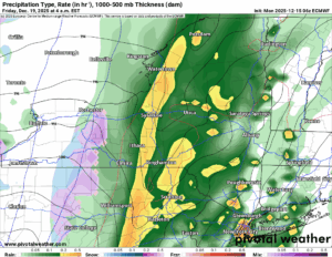
Thursday Night and into Friday AM will be the time for rain showers and temperatures locked in the 30s and 40s. Even in the middle of the night. That should screw up the top 10 coldest Decembers marks we are chasing. The rains will add up. How much? If it was going to be 1 to 2 inches, I would be sounding the alarms now. I am not sure about this yet. Let me have a few more model runs and get back to you on this tomorrow.
This weekend we return to snow showers with lake effect especially off of Lake Ontario. No idea where this is going yet since we are 6 to 7 days away. Just know that it is out there and will make a calling on someone. Probably to the north.
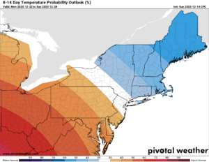
8-14 Day
This is the battle zone. We are the battle zone. 100 to 200 miles south and west, I am telling you, 50s and 60s will definitely not be out of the question. 100 to 200 miles to the north and east, I can tell you below zero is very possible. Where do we end up? In the middle of the freaking ROLLER COASTER RIDE! Expect HUGE SWINGS in temperature heading through Christmas and into the week between Christmas and New Years. We will see what happens from here.
NYSSA Public Trail Map
If you would like to advertise on the site, reach out anytime!
VENMO: @Zman291
CASH APP: #ZACKLUPIA
Zack and Rich Lupia
Upstate Snow
December 15, 2025
Please thank our advertisers on Upstate Snow!
Business Sponsorships
Ohio Ridge Riders
Enjem’s Flooring America
ilsnow.com
Saratoga Snowmobile Association
Southern Tug Hill Snow-Riders
Business Members
John Schoff Polaris Memorial Ride
Personal Members
James Andre
Eric Vilovchik
Charles A. Klesse Sr.


