
The Morning Blog is brought to you by the Tupper Lake Snowmobile Club! Servicing Franklin County and surrounding areas, these folks do everything they can to make your snowmobile ride an awesome on every time! And in case you didn’t know, it is one of the favorite “launch” sites for DARRIN HARR and the ILSNOW.COM BANDWAGON. To access the club’s Facebook Page CLICK HERE.
Good Morning. Today is THAW day. This is not the day we have waited for, however, don’t forget that in nearly every winter we have, no matter how bad it gets, we usually have at least a few days like this. Just be thankful this is a “bump in the road” and not a pattern of being crushed by garbage plates!!!

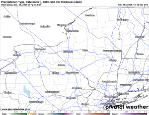
4 PM TODAY
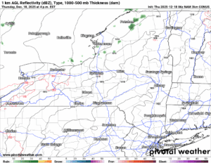
Today temperatures will soar into the 40s. The winds will increase during the day, getting stronger this afternoon and particularly this evening. Clouds will be on the increase from west to east across the state as we head through the day.
4 AM TOMORROW MORNING
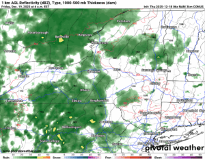
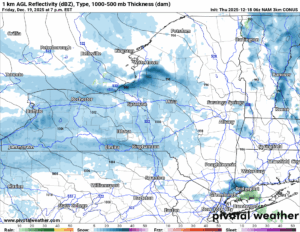
Tonight the winds are strong and this is when the WIND ADVISORIES kick in across the state. Literally, the entire state of NY including NYC and Long Island. Wow! Three Counties, Chautauqua, Jefferson and Lewis Counties have gone to HIGH WIND WARNINGS for this event. We will see what changes as this event unfolds. With the wind will come the rains. Lots of rain. It will be the worst after midnight. Expect steady rains by the time the sun comes up on Friday.
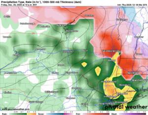
10 AM TOMORROW MORNING
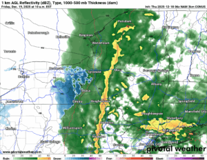
Then at 10 AM tomorrow. All of the maps from the GFS to the NAM to the EURO to the HIGH RES NAM showing a near squall line Friday Morning at 10 AM across the state from Canada to Pennsylvania. An intense line of rain along with thunderstorms LIKELY within this band. This will be the worst of the rain, warmth, and the melting, not just because the winds are strong, but temperatures will be in the 40s to low 50s areawide. Areas with less than a foot of snow are in great danger of not being able to open up after this storm rolls on through.
1 PM TOMORROW AFTERNOON
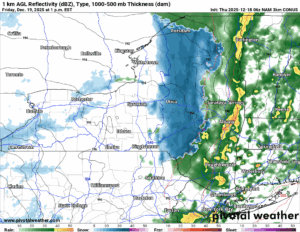
Then the storm rolls on through. The 40s/50s become 20s/30s in a dang hurry! The winds behind the storm turn to the WNW to NW and get even stronger. Some of the biggest gusts, 40-60 MPH gusts, with even higher amounts in WNY, I call for on Friday Afternoon along with the sharply falling temperatures and the rain changing to snow. In a hurry!
7 PM TOMORROW NIGHT
Friday Night we actually have the return to some lake effect snow! Will it be a ton? Nope. But it will be enough to put back some of what will have been lost on the snowpack. For those areas that maintain a snowpack and hang on through this storm in the next 36 hours: you will be in GREAT SHAPE. Because you will finally have A BASE OF SNOW. To build on!
9 AM SATRUDAY
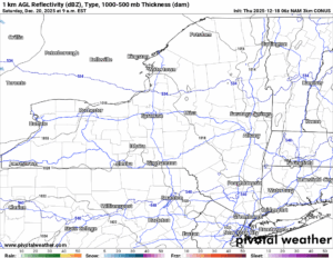
Saturday is dry with a mix of clouds and sun. The winds die down finally. The temperatures will be in the 30s during the afternoon. Some spots may get close to 40. It will be brief but I do not expect much additional melting or compaction.
10 AM SUNDAY
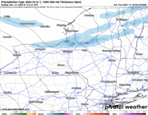
Sunday is the next system with scattered snow showers and some minor lake effect snows. For most just a dusting to an inch or two. Localized areas could see more.
10 AM TUESDAY
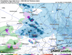
Day before Christmas Eve is looking messy again. Nowhere near as crazy as tomorrow’s storm will be. But we will see snow showers, change to rain briefly, then change back to snow with some minor accumulations possible heading into the morning of Christmas Eve.
7 PM CHRISTMAS EVE
Christmas Eve and Christmas Day are expected to be QUIET. And cold, but seasonably cold. For many of you, it will be the first White Christmas in many years! Some will not get that, especially those without a lot of snow now. We’ll see.
10 AM DECEMBER 26TH
Then the day after Christmas… let’s just say… it’s Day 8 and this means that I am in the “I am watching” stage more than I am going “into a panic” stage. Kind of like I am with this thaw that is about to hit!
Stay safe out there and be careful whatever you do today, tonight and tomorrow.
NYSSA Public Trail Map
If you would like to advertise on the site, reach out anytime!
VENMO: @Zman291
CASH APP: #ZACKLUPIA
Zack and Rich Lupia
Upstate Snow
December 18, 2025
Please thank our advertisers on Upstate Snow!
Business Sponsorships
Ohio Ridge Riders
Enjem’s Flooring America
ilsnow.com
Saratoga Snowmobile Association
Southern Tug Hill Snow-Riders
Business Members
John Schoff Polaris Memorial Ride
Personal Members
James Andre
Eric Vilovchik
Charles A. Klesse Sr.


