
The Morning Blog is brought to you by the North Warren Trailblazers! NWTB members devote thousands of hours preparing and maintaining the 80+ miles of groomed trails each year. The trail system winds through the picturesque New York State Adirondack Mountains just north of Lake George in Warren County, and connects Brant Lake, Chestertown, Pottersville, Warrensburg and Lake George. If you want to get this scenic view of the Adirondack Mountains CLICK HERE FOR MORE!
WE ARE SORRY! WE SCREWED UP BAD YESTERDAY!
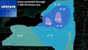
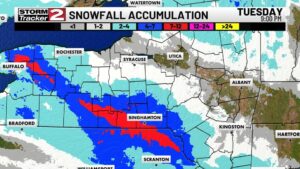
Holy cow! We had no idea we could miss this badly at this point. Yikes! Nothing from Utica to Albany (With a 2-4 and a 4-8 surrounding it), but meanwhile across a lot of the Dusting to 2″ area, we had 5-10 inches. This is not getting funny. Especially since we want to be dead on heading through Christmas and into the New Year being as good as possible.

Or at least, RELIABLE 🙁
HO HO HO!
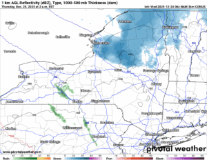
As Santa’s Sleigh flies by later tonight, will he bring snow with it? The NAM 3K Model says YES across the Adirondacks and the Tug Hill! But remember recent history and what the models showed then what happened! You never know 🙂
1 PM FRIDAY

OK so going off of the 60 Hour NAM 3K, the edge of this range, it shows snows spreading into Western NY. Rains down in Pennsylvania, but those rains will not get here. We are on the cold side of this storm. Later by Friday Night, it could get tricky for travel again!
7 PM FRIDAY
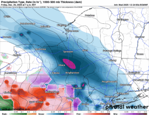
Snow. Heavy at times. Moving out of Western NY and into Central NY and the Southern Tier. This means overnight Friday and into Saturday Morning, it will be the Adirondacks, Capital Region and the Hudson Valley’s turn at this. There will be accumulations with this storm. A few inches definitely. Several inches possible to likely. Not sure how exactly the NWS will handle it, but lets get closer and find out Christmas Night tomorrow night or on Friday Morning.
1 AM MONDAY
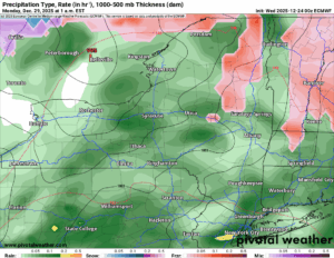
What do we have here? Is that a low going to our North and West. Sleet/Mix to rain out ahead of it? Yep! That is what it is showing for late Sunday and into early Monday as of right now. So if your travel plans are in this range as of now, you have your “travelers advisory” to keep watch on that time frame and time to make alternate arrangements if you can.
7 PM MONDAY
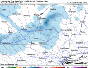
Much colder air with snow showers and lake effect squalls will be coming on down during the day on Monday. Expect a morning high on the 29th then falling temperatures during the day. A secondary cold front will move on in by Monday Night and that will enhance the snowfall then bring additional lake effect behind that storm.
HAPPY NEW YEAR!
Really? This is how you want to say HAPPY NEW YEAR to us? WHY THANK YOU VERY MUCH! This will help us out big time because we are finally getting within sight of a big date: January 2nd. It’s 9 days from today. But it’s very important because that’s the day THE REST OF THE STATE OPENS FOR SNOWMOBILING. Keeping an eye out for you.


THANK YOU BILL KARDAS!
With next month being the 20 year anniversary of Bill Kardas at WKTV (over 10 years of it as chief), we had the chance to look through and came up with a few pictures that reminded me of my WKTV home of old. It was January 2006, 20 years ago next month when he started, and we wanted to show you photos from that time.
You Tube was just invented and so was Facebook. Although we had seen neither of them yet at that point in time. MySpace was the big thing. Cars had not come out yet. And 2006 would be the last year we would use the Oneida County Airport as our main information station. It was the only one we could use between 1995 and 2007 until Griffiss returned and has been back there since. Anyway, thanks for my trip down Memory Lane.
MERRY CHRISTMAS TO YOU AND YOUR FAMILY!
From my family to yours we wish you nothing but the best. Have a VERY MERRY CHRISTMAS! We will not be putting up a report tomorrow morning (did you say: PRESENTS?!?!). Yes I did. A lot of them. And we will have post mortem on Christmas and a look at the crazy weather to come after that by Friday Morning.
NYSSA Public Trail Map
If you would like to advertise on the site, reach out anytime!
VENMO: @Zman291
CASH APP: #ZACKLUPIA
Zack and Rich Lupia
Upstate Snow
December 24, 2025
Please thank our advertisers on Upstate Snow!
Business Sponsorships
Ohio Ridge Riders
Enjem’s Flooring America
ilsnow.com
Saratoga Snowmobile Association
Southern Tug Hill Snow-Riders
Business Members
John Schoff Polaris Memorial Ride
Personal Members
James Andre
Eric Vilovchik
Charles A. Klesse Sr.


