
The Morning Blog is brought to you by the Ohio Ridge Riders! This club is one of the oldest in New York State! It is home to SNOW BASH every September, which is the kickoff to us for every season since 2012! There were nine members at the first meeting in 1968. By the end of the first year there were 131 members. The first annual Ohio Ridge Riders clambake was held in August of 1968 and later turned into the Snow Bash in 1992. Snow Bash being over 30 years old now draws tens of thousands to the town of Ohio each September, easily the areas largest event! For more information on the club CLICK HERE!
OH $#!? HERE WE GO!
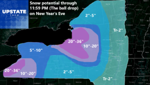

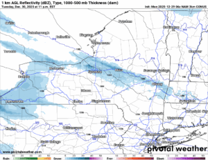
Between extending this into almost another full day of lake effect snow plus actually increasing the amount of snowfall coming down from the changeover this afternoon through early Wednesday Morning: it means lots of snow! Will it be a generational event like last January 1-5 was or last February break when we had all the roof collapses in Oneida, Oswego, Lewis and Herkimer Counties? I don’t think so. BUT: The fact I greatly increased this number over the last 12-24 hours is not a good sign, Plus the fact we are near the event and in the range of the high resolution data with this. All of which the data is screaming SNOW BABY!!!
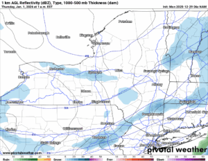
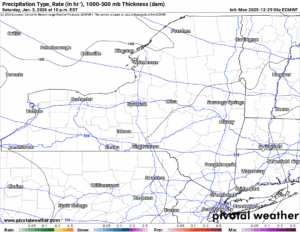
Rain changes to snow quickly this afternoon as temperatures come crashing down. The snow, particularly this evening, will be heavy at times along with bands of heavy lake effect snow. Looking at areas seeing 1 to 2 inches per hour is not out of the question here. And for the evening commute tonight and morning commute tomorrow, through these areas, IT WILL BE ROUGH! In addition, THE WINDS! Don’t forget about the WINDS! Blowing 35-55 MPH with gusts in Western NY and up in the Watertown area between 55 and 75 MPH! That will definitely cause trouble. At the very least! As for the temperatures, with it falling into the teens, plus the strong winds, expect wind chills to go BELOW ZERO!
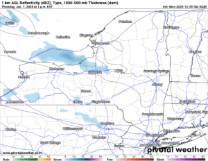
Tuesday expect snow showers with bands of heavy lake effect squalls to continue. It will not be a 24/7 thing. There will be periods where it will be heavier and others to where it will not be as much. There will still be tricky travel with several additional inches expected.
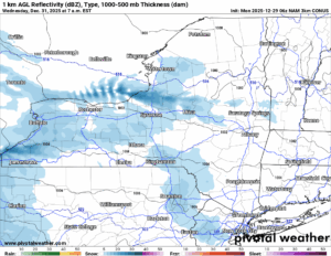
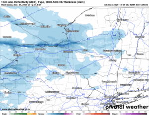
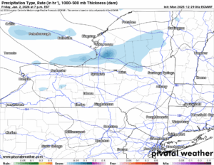
On New Year’s Eve in the morning heading into the midday, another trough rotating around the big low pressure up in Canada will swing on through. This will enhance the lake effect snows on Wednesday morning and midday with another several inches possible over areas that may not have seen all that much to this point. It will have been cold enough by this point to where it’s all snow by far with temperatures everywhere below freezing. Winds will have died down somewhat.
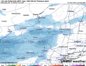
RING INTO 2026! The trough moves through, and the air turns a bit colder with instead of teens, we are looking more like single digits to maybe below zero up north of the Thruway. The snow showers begin to fall apart some by the time the ball drops into 2026. The worst of the snows will be over by this point in time.
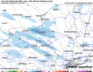
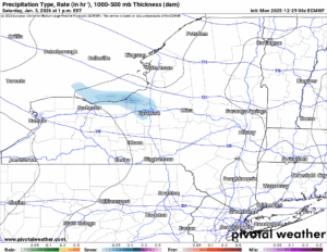
Into 2026 we go with just scattered snow showers otherwise a mix of sunshine and clouds. Additional lake effect snows off Lake Erie but particularly off of Lake Ontario will still be in play. There will be additional accumulations but they will be more localized and no where near as much as between now and the ball drop.
By the weekend the event finally ends and we can take a breather. Any additional snows we get on the 1st and the 2nd (nowhere near as much as over the next three days) we can finally dig out of by next weekend. Great to heat that on a Monday I know, but at least the kids are off from school so you will have some extra help!
Also the whole state will open to snowmobile riding as of Friday. It all depends on how much snow we get and how much is sticking around over this week and after all the holiday traffic gums up the trails. Who knows how it will look! One thing I do know: It will be a great week for snowmobiling! The best in 8 years at this point in the season!
NYSSA Public Trail Map
If you would like to advertise on the site, reach out anytime!
VENMO: @Zman291
CASH APP: #ZACKLUPIA
Zack and Rich Lupia
Upstate Snow
December 28, 2025
Please thank our advertisers on Upstate Snow!
Business Sponsorships
Ohio Ridge Riders
Enjem’s Flooring America
ilsnow.com
Saratoga Snowmobile Association
Southern Tug Hill Snow-Riders
Business Members
John Schoff Polaris Memorial Ride
Personal Members
Francis Miller
James Andre
Eric Vilovchik
Charles A. Klesse Sr.


