
This blog is brought to you by the Columbia County Sno-Drifters. 25 years ago a group of friends got together and said, HEY, WE NEED A SNOWMOBILE CLUB HERE! They made it happen. Over the coming years through losses, and through landowners not being as particularly nice towards these parts of the state, they still have have been able to keep the club going and maintained with miles of trails through the Chatham area, Copake, and Valatie. Thank you for your support of snowmobiling in Columbia County! For more information, CLICK HERE.
I am sorry.

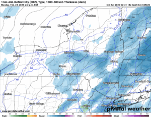
These weeks with hardly anything going on, then all of the sudden, THE BIG ONE happens. It’s not for anywhere in our counties, it is definitely southbound of us. However, if you are in the TRI-STATE AREA, NYC AREA, PHILLY, HARTFORD, PROVIDENCE OR BOSTON, EXPECT TO GET A POTENTIALLY TOP 10 FEBRUARY, IF NOT TOP 10 ALL TIME SNOW STORM. THAT IS NOT on this map. However, just beyond the map, as you play these numbers out in your head, you can see how exactly we get there as Meteorologists.
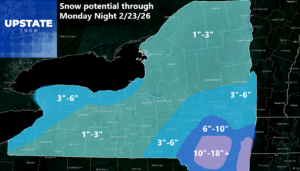
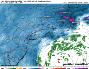
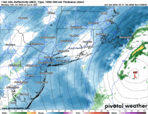
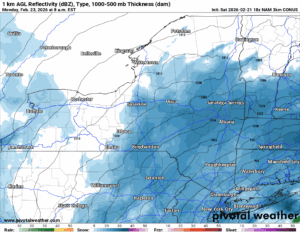
This starts tomorrow morning. It increases in intensity in the afternoon. Sunday Night and into Monday Morning this storm is going BOMB-O-GENESIS. We are talking like 30-40 mb in 24 hours. So this means a 1000 mb storm in 24 hours becomes a 970 to 960 mb storm. What does that mean for me?

AT SEA
Waves 25-50+ Feet. Constant storm force to hurricane force winds. During the greatest times of winds, they will easily be category 1 level hurricane force, if not low end category 2 hurricane force. Not something anyone should be in.

NEAR THE COAST
Waves 15-30+ Feet. Constant storm force to possible hurricane force winds. With snow being the main precipitation type and temperatures falling below 32, BLIZZARD CONDITIONS WILL RULE. Remember the rules for a Blizzard: Minimum 35 MPH winds for 3 straight hours, 1/4 miles visibility or less, any type of snow falling at any intensity. We have seen blizzards dump 2-4 inches and hour. We have seen them dump 12″ in 24 hours. Who knows.
INLAND BUT NEAR THE COAST
Winds 25-50 MPH with gusts above that. Heavy snows with near blizzard to blizzard conditions expected. The farther away from the coast you are, the less snow you will receive.
This all moves out Monday afternoon and especially by Monday Night. We will be done with snowfall through the day on Tuesday. Wednesday will be a different story.
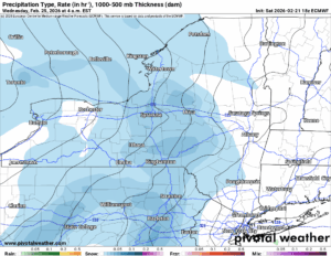
Next storm system rolls on in with snow showers. Since temperatures will be near freezing the water/mix ratios will not be as high.
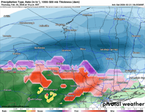
After a quiet day on Thursday, yet another storm moves on in Thursday Night and into Friday. This one also has temperatures near to above freezing so ratios will be different with the rain and the snow that would be expected to fall.
HEADING INTO MARCH
It looks like we are heading into March LIKE A LION. At least that is the way I see things. The temperatures will start to swing wildly all over the place. Don’t worry. It’s this time of year. Even though it will probably work out to be more above normal than below normal.
DOWNLOAD THE 2026 NYSSA SNOWMOBILE INTERACTIVE MAP! It has on it and available which trails are open, closed, and major hazards that are out there, where and when. It is a great gift for you to download to your iPhone or Android TODAY!
NYSSA Public Trail Map
If you would like to advertise on the site, reach out anytime!
VENMO: @Zman291
CASH APP: #ZACKLUPIA
Zack and Rich Lupia
Upstate Snow
February 21, 2026
Please thank our advertisers on Upstate Snow!
Business Sponsorships
Ohio Ridge Riders
Enjem’s Flooring America
ilsnow.com
Saratoga Snowmobile Association
Southern Tug Hill Snow-Riders
Business Members
John Schoff Polaris Memorial Ride
Personal Members
Chris Schoff
Francis Miller
James Andre
Eric Vilovchik
Charles A. Klesse Sr.


