

Those of you whom were awake and alive on Thursday October 12, 2006, had a little bit of a rude awakening and a WELCOME TO WINTER in among the biggest October ways in history. The snow started coming down late morning and by afternoon and especially the night of the 12th it was snowing at 1-2 inches per hour in spots. The lake effect snow was intense! Given the air temperatures were around freezing, the air was mixing up above 20,000′, higher than normal for lake effect snow events, and it just kept rolling through the rest of the day and into the 13th before ending later that day, this storm was one to remember. We will go more into the specifics on this lake effect storm off of Lake Erie later in the blog.
This is right up there with the 1987 storm in Eastern NY, the 2008 storm in Central NY and the 1993 Halloween Nor’easter in Central and Eastern NY among the biggest October snowfalls in history.

Speaking of which, we haven’t truly gotten a big October surprise since 2008. We are at 18 years and based upon how often we have gotten hit in the past, I would think we are due again. I will tell you I do not think this is the year. More on that later in the blog.
THE STORM
Lake Storm Aphid was the name given this storm on this date 20 years ago today. There was already precipitation as the cold front moved through first thing in the morning. The temperatures kept falling, the air kept getting colder aloft, and the lapse rates kept getting steeper. Just after lunchtime is when the transition started to happen in the City of Buffalo. Depending on where you were in Western NY it may have been different. But the rain went to a mix just after noon. During the 1 PM hour, the mix went to more of a sleet and ice. By 2 PM, it dropped to 34 degrees and officially went all snow. Two hours earlier it was 41. This is how Mother Nature can play with you.
The snow continued during the afternoon but mainly stayed in the grassy areas between 2-6 PM. Although snowfall rates approached 1″ per hour and thunder was booming at times, it was still not enough to really accumulate on the ground. Yet. That would change shortly.
After 6 PM, ALL HELL BREAKS LOOSE!
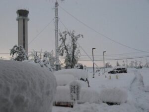
This is when tree after tree starts crashing down across Buffalo and in the suburbs. Cars get squashed. People are calling the NWS Buffalo office like it’s going out of style. The next 12-14 hours after this would be the worst period of snow in Buffalo’s October history. 22.6″ at the NWS Office, 3″ of it before 6 PM, but the other 19.6″ inches of it in the next 14 hours. Thunder everywhere. Trees crashing everywhere. Power out for hundreds of thousands. In some cases power wouldn’t come back for some for a week to 10 days. The storm ended by Noon on the 13th. 15 people died. There was a mountain full of debris to clean up. Many of the older Buffalo area trees did not survive this storm. Here were the final snow totals:
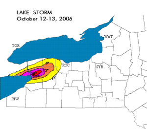
STORM TOTALS
Lancaster – 24″
Amherst – 24″
Depew – 24″
Cheektowaga – 22.8″
NWS Buffalo – 22.6″
Towanda – 15″
West Seneca – 14″
Batavia – 10″
Medina – 8″
Orchard Park – 8″
Lockport – 7″
Brockport – 3″
WHAT IS HAPPENING THIS OCTOBER OF 2026?
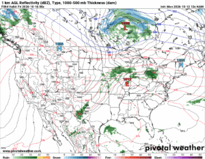
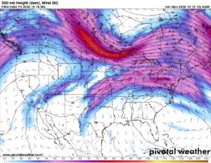
Well, I am glad you have asked. It is looking more and more INTERESTING as we are looking at this weekend. Take a close look at the latest 12Z NAM from this morning across the US and southern Canada. You can see the big ridge in the Southeast US and the big ridge developing in the western US. Take a look over the northern Plains and into southern Canada. THIS IS NOT GOOD! This is why I had said something yesterday. Now I am saying more about it today as instead of us being 150 hours away, we are now 120 hours away. We are just over one more day before the high resolution models get pinned over us for the weekend. I can tell you how I have been seeing this over the last 2 days. The trend is getting colder. Highs not looking to get out of the 40’s this weekend is pretty much a lock now. Only questions are this:
1) Is there ANY snow with this storm this weekend, especially higher up
2) If so, how much?
One thing I can say with 1000% confidence, IT WILL NOT BE A REPEAT OF THE BUFFALO STORM 20 YEARS AGO. NOT EVEN CLOSE. HOWEVER… I am liking the trends here for snow showers, perhaps a dusting and maybe more, at elevations above 1000′ to 1500′. We still have time to watch. The trend is your friend. I am liking the trend.
We are still not at the point of putting out accumulations map. Yet. That’s more of a Thursday thing. I know others will put it out sooner. Others will put it out now. Let them do their thing. We appreciate you letting us do ours, with a 29 year Meteorological Veteran and his 23 year old son leading the way.
Zack and Rich Lupia
Upstate Snow
October 12, 2026
PLEASE THANK OUR SPONSORS FOR THE 2026-27 SEASON!
Business Sponsors
Enjem’s Flooring America
Ohio Ridge Riders
ILSNOW.COM
Personal Member
Charles A. Klesse Sr.