
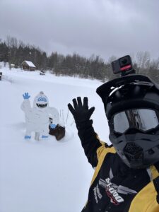
This Morning Blog is brought to you by the Chittenango Polar Bears Snowmobile Club! This club maintains trails in Madison and Onondaga Counties and into the hills to the south towards Cazenovia. Over 60 total miles of trails are included in the system. Get out and ride but please always do so safely! This is a busy area of trails in Central New York! For more information CLICK HERE.
It is President’s Day 2026. We formally welcome you to the BACK 9 OF WINTER. From this point forward, the sun angle will be increasing significantly daily. To the point to where if there is any sunshine out and there is any asphalt underneath, expect the trails to burn out. Fast. It will happen even faster as the days wear on. More and more we are going to have to rely on temperatures at or BELOW NORMAL from this point forward.


Here is a look at the snow cover as of TODAY across all of Upstate NY. Seeing a how we JUST BROKE FREEZING for the first time in a month, one of the longest streaks we had in over a decade if not over two decades, it is amazing how many weeks in a row the entire state has been ready to ride. And enjoying themselves!
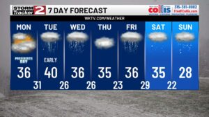
Looking ahead to the weather this week, this was initially a big concern last week as it was looking squarely ABOVE NORMAL during President’s Week. But as the days have approached and now we are here, it will still be above normal, but not by much. Only by a few degrees on the high temperatures but definitely more so on the low temperatures. You notice the drop off on temperatures heading into next week, the last full week of February. More on that in a moment. In the short term, expect a little bit of melting, settling and compaction over the next two days. The rest of today and tomorrow it will be like this.
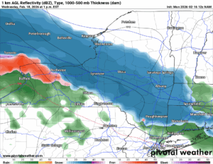
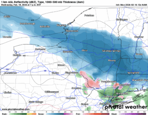
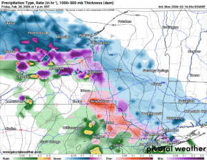
Wednesday will be a tough storm. This was initially looking warm and wet everywhere. Then it suddenly shifted cold. Now it is at the borderline. If you are in the Capital Region, Eastern NY and the Champlain Valley, expect SNOW. If you are in the Mohawk Valley, The Adirondack and the Catskills expect a MIX. Tug Hill, Central NY, The Southern Tier, expect a MIX to RAIN. To the Finger Lakes and Western NY expect RAIN. That’s the way it is looking as of 12Z Monday. With several more model runs to go and all kinds of quirky things between now and then: If you have been with me for any length of time, you know how this could go!
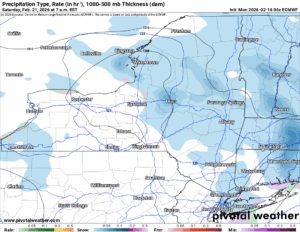
Once the Wednesday storm moves out it should be quiet and mainly cloudy on Thursday. Temperatures will be above freezing but not by all that much. There will not be a whole lot of melting happening. Another system moves in on Friday with rain showers and snow showers. It will mix at first, but as we head into the weekend, colder air moves in. It will mix with then change back to snow over the weekend and by Sunday all areas are below freezing and back into the SNOW. That is good 🙂
 .
.
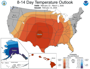
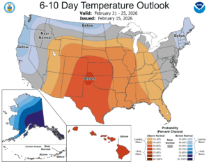
The 6-10 and 8-14 days say through the rest of February and into the first few days of March, we should be near normal. Maybe slightly above. Maybe slightly below. Most days will be in the 30s so any melting or compaction of the snowpack will be slow. Overnight lows well below freezing.
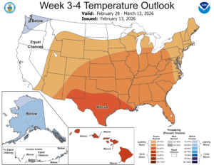
Week 3 and 4 is new and out and this has potential trouble for us. Remember March’s getting warm on us in recent years? Yep this one is indicating another possible warmup heading into March. If this map does happen and this is how everything plays out, how would I expect it to handle the trails around the state? I would expect in the first week of March most of the Finger Lakes, Southern Tier, Western NY and the Capital Region will have their last days in of sledding before shutting down for the season. In the second week of March that could carry into Central NY, the St. Lawrence Valley, and possibly the Catskills and the Mohawk Valley. It is very easy to think we could ride the entire state today if you really wanted to. But by March 15th, especially with temperatures getting warm in week 3 and 4, a lot of the state will start to melt away. We will only be left with the Tug Hill and the Adirondacks by the 15th of March. And I would anticipate, unless another really cold shot or more snows came back in the second half of March, that all snowmobiling in New York would be over with by April 1st. Except for a few “die hard” trails, by April 1, we would all be done. And into “summer sucks” season.
DOWNLOAD THE 2026 NYSSA SNOWMOBILE INTERACTIVE MAP! It has on it and available which trails are open, closed, and major hazards that are out there, where and when. It is a great gift for you to download to your iPhone or Android TODAY!
NYSSA Public Trail Map
If you would like to advertise on the site, reach out anytime!
VENMO: @Zman291
CASH APP: #ZACKLUPIA
Rich Lupia in SC (for Zack in New York!)
Upstate Snow
February 16, 2026
Please thank our advertisers on Upstate Snow!
Business Sponsorships
Ohio Ridge Riders
Enjem’s Flooring America
ilsnow.com
Saratoga Snowmobile Association
Southern Tug Hill Snow-Riders
Business Members
John Schoff Polaris Memorial Ride
Personal Members
Chris Schoff
Francis Miller
James Andre
Eric Vilovchik
Charles A. Klesse Sr.


