
The Morning Blog is brought to you by the West Rome Riders Incorporated of Rome, NY! This group also holds the John Schoff Polaris Run, an annual event which takes place in the second Saturday of January. That just happens to be this upcoming Saturday. Even though it will NOT be snowmobiling weather on Saturday (well above freezing with showers, especially in the afternoon), PLEASE come out to support the Schoff family as they have been major contributors to the sport not just locally but regionally as well. For more information about the club and their trail system, PLEASE CLICK HERE.
Good Morning! With Winter Weather Advisories up and a mix of rain, snow, sleet and freezing rain, we have not lost much of anything over the last 48 hours. Which is a blessing. Because the next 96 hours, or next 4 days, between RIGHT NOW and EARLY SUNDAY MORNING, we are OFFICIALLY in our JANUARY THAW. This is THAW #2 this winter. The first thaw was harsh and took a lot down out of us but we have been able to steadily build back the snow pack to this:

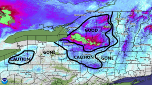
Here is the current NYS snowfall map as of this morning. There is, outside of the Lake Erie bands to the south of Buffalo, next to nothing left for folks to ride in general south and west of a line from Auburn to Groton to Binghamton. Within the next four days, especially on Friday, that snow will go BYE BYE. Where there is deeper snows CAUTION is laid out across the areas south of Buffalo, the Syracuse area and points south and east plus the St. Lawrence Valley. The rest of New York, the Utica/Rome area, Mohawk Valley, Adirondacks, Tug Hill and North Country should have enough to BRACE FOR IMPACT over the next several days before winter like weather returns on Sunday. Until then, the melting today, tonight and tomorrow will be slow. It will not take off like a rocket yet.
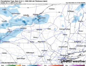
FRIDAY
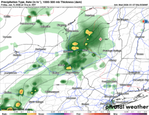
Not until Friday will it take off. See the several bars scattered across the Empire State? This is indicative of strong southerly winds of 20-40 MPH with higher gusts. Friday is the day of most concern as the temperatures will be the warmest, the winds will be strongest, and the melting will obviously be the fastest.
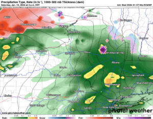
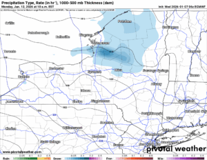
SATURDAY AM
On Saturday morning we catch a break in the winds and with the precipitation. If there is a point in which we can clean up or otherwise take stock of how things are around here, it is looking like Saturday Morning would be best. That also happens to be the time for the John Schoff Polaris run in Rome so definitely bear that in mind.
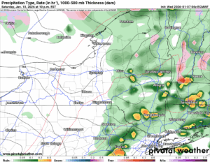
SATURDAY PM
Rain returns Saturday afternoon and into Saturday evening for one more round. It will not be as windy or as warm as Friday, however, it will still still be way above freezing with rainfall so expect snow to continue to melt.
SUNDAY PM
The cold front clears us Sunday morning, early highs of 35-45 will be falling during the day as any rain changes quickly back to snow in the morning then stays as snow showers in the afternoon. Since it is behind the system, there will not be much left with it. Maybe a dusting to 2″ but even a call like that is nearly too far out to make right now.
MONDAY
With the exception of some lingering snow showers and minor lake effect to the north of the Mohawk Valley, some sunshine returns to the region on Monday with temperatures expected to be right exactly where they are supposed to be for this time of year. Right around 30 degrees with 20s in the higher elevations. It will be great just to have a normal day with partly sunny skies. A BREAK DAY! MY GOSH A BREAK DAY! WOO HOO!!!
We will advise as we get closer just how warm and windy it will get on Friday, how much snow pack we will probably lose, and what should be left for us to enjoy starting next week.
NYSSA Public Trail Map
If you would like to advertise on the site, reach out anytime!
VENMO: @Zman291
CASH APP: #ZACKLUPIA
Zack and Rich Lupia
Upstate Snow
January 7, 2026
Please thank our advertisers on Upstate Snow!
Business Sponsorships
Ohio Ridge Riders
Enjem’s Flooring America
ilsnow.com
Saratoga Snowmobile Association
Southern Tug Hill Snow-Riders
Business Members
John Schoff Polaris Memorial Ride
Personal Members
Francis Miller
James Andre
Eric Vilovchik
Charles A. Klesse Sr.


