
The Morning Blog is brought to you by the Brantingham Snowmobile Club of Lewis and Herkimer Counties of New York. This club is wide and expansive with over 120 total miles of trails to groom and maintain from the lower elevations (mainly closed at this time) by the Black River, to stuff way up above 2000′ in the Western Adirondacks (Open for smooth sailing!). And everything in between. For more information PLEASE CLICK HERE.
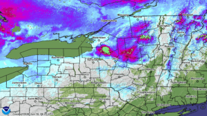
Many folks in Central and especially in Western NY got several inches of snow yesterday. Some localized spots almost got a foot of snow! It was definitely a winter day with falling temperatures and howling winds along with blowing and drifting of snow. That will calm down as the day progresses. But not for long! Our next system is coming up fast and it will be here tonight before you know it!

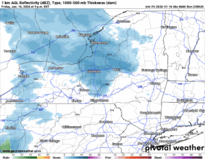
Tonight our warm front approaches from the south and the west. It develops occasional light snow over us this evening and into the overnight. It is actually continuing tomorrow morning as our clipper system approaches us and gets set to pass us late morning or around midday tomorrow depending on where you are in the state.
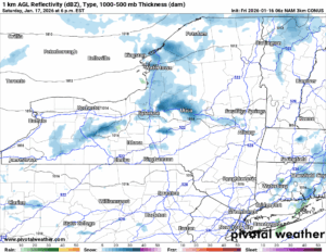
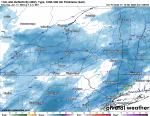
The snow showers continue on and off through midday then become more scattered in the afternoon and into the evening, but the snow showers still hang on near and just downwind of Lake Ontario and Lake Erie. Again this is a clipper, this is not what I would call a big event, especially at this juncture in the season:
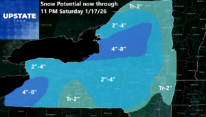
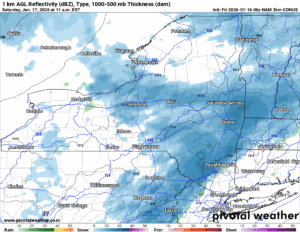
As you notice through tomorrow night the heaviest accumulations are downwind of Lake Erie and Lake Ontario, otherwise no more than a few inches. 4 inches would be my top end of the forecast in the areas outside of the Lake Effect zones. Sunday is a quiet day here as the storm well to the south, stays well to the south and out of the way.
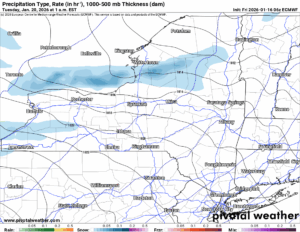
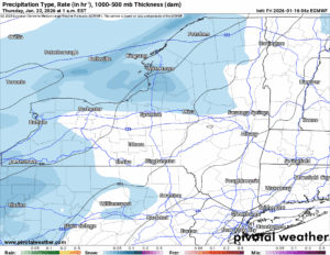
Overnight Monday (MLK Day) and into Tuesday another front comes through with a clipper and mainly lake effect snow. It will be dang cold then with overnight lows NOT staying above zero north of the Thruway. The next map is for Wednesday Night into Thursday Morning with yet the next clipper system with light snow showers followed by quick Lake Effect and then we are back off and running.
I apologize. I know we are at 6 straight weeks with almost nothing but clouds. Sunshine in some areas has lasted, literally over the last six weeks, in minutes. Not hours. We go through these stretches but not every year. When we do, it is absolutely rough on us. Particularly folks like me who like the sunshine. I guess we will just have to leave things the way they are for now, won’t we?
NYSSA Public Trail Map
If you would like to advertise on the site, reach out anytime!
VENMO: @Zman291
CASH APP: #ZACKLUPIA
Zack and Rich Lupia
Upstate Snow
January 16, 2026
Please thank our advertisers on Upstate Snow!
Business Sponsorships
Ohio Ridge Riders
Enjem’s Flooring America
ilsnow.com
Saratoga Snowmobile Association
Southern Tug Hill Snow-Riders
Business Members
John Schoff Polaris Memorial Ride
Personal Members
Chris Schoff
Francis Miller
James Andre
Eric Vilovchik
Charles A. Klesse Sr.


