
The Morning Blog is brought to you by the Deerfield Snow Trails of Deerfield, NY in Oneida County, covering miles of groomed trails in the northern suburbs of the Utica area. This club has a different name and organizational reach in decades prior to 2005 but in this year 21 years ago, decided it was time to make a switch and get better organized. And they did. You ride many miles of these scenic trails to the north of Utica with the Adirondacks on the horizon, it’s probably us! For more information CLICK HERE
Good Morning! Happy Martin Luther King Jr. Day and for those enjoying the three day weekend, I hope you are enjoying the extra time off. I also hope you all are well bundled up and prepared because there is MAJOR COLD heading this way. It will be getting here this afternoon and tonight, will be here through the day Tuesday then the snow continues through Wednesday before tapering some Wednesday Night. So with this being the case, here is the BIG snowfall forecast then an explanation afterwards.

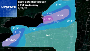
OK. TONS OF SNOW south of Buffalo, especially the South Towns and the Southern Tier. East of Lake Ontario between Watertown and Oswego… BAM! Does Utica/Rome or the Mohawk Valley get in on this one? Nope. It is looking to stay north this time with huge swaths of snow predicted over short distances. One town, barely anything. Next town on the edge. Next town anywhere from 2-4 feet! Yes, that is how crazy this localized lake effect goes. Those whom have followed us for a long time already know this. But also I have thousands of new faces on here over the last few years and without many big winters they may not be as able to identify with what I am talking about. Just trying to put 2 and 2 together.
BOTTOM LINE FOR SNOWS THROUGH WEDNESDAY EVENING
Buffalo North: Most of it now through this evening. Some more on Wednesday.
Buffalo South: Tonight through Tuesday. Additional on Wednesday
Rochester Area: Most of the snow comes later today. You get a break tomorrow. Back at it on Wednesday.
Watertown/Ft Drum and South: BURIED. Travel will be impossible at times with totals of 24-48 inches+
TUG HILL: BURIED. 24-48″+ but I would call that on the northern half of the hill. Southern half gets a lot less this time.
Adirondacks: Southern is 2-6 inches. Central is 6-12 inches. Northern is 12-24 inches but likely closer to 12 especially east
St. Lawrence Valley and up to the Champlain Valley: 2 to 6 inches. I realize I may be high in the Champlain Valley.
Syracuse, Ithaca, Elmira, Binghamton, Hudson Valley, Capital Region and the Mohawk Valley: SITTING THIS ONE OUT
NOW THE DETAILS
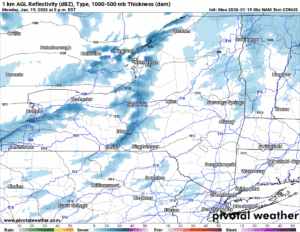
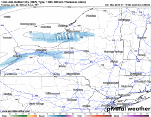
6 PM THIS EVENING
11 PM THIS EVENING
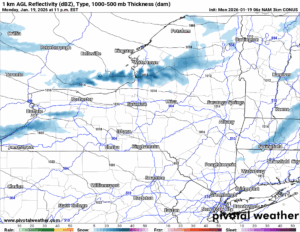
The bands of lake effect snow, heavy at times are already hitting areas north of Buffalo and Watertown. As the winds shift and as the colder air comes pouring on in along with those gusty winds tonight, this will be the period when a majority of people in the heavy accumulations (12″ or higher) will see the majority of their snow. This evening and into the overnight hours. Winds of 15-30 with gusts to 45 MPH along with temperatures crashing into the single digits and the single digits below zero, not counting the wind chill, will make it borderline dangerous out there. BE PREPARED!
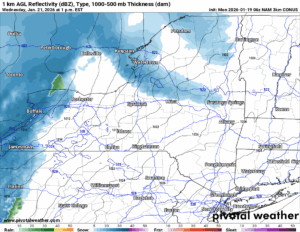
1 PM TOMORROW AFTERNOON
8 PM TOMORROW NIGHT
Tuesday during the day and into Tuesday evening, the winds will gradually die down. Not so much in the morning but in the afternoon and evening. The areas outside of the lake effect are probably going to go PARTLY SUNNY with the very cold and dry air in place with the state in between systems. In the areas south of Buffalo and Watertown that unfortunately get the lake effect: Just remember. It’s going to be big! Heavy snow at times. Whiteout conditions.
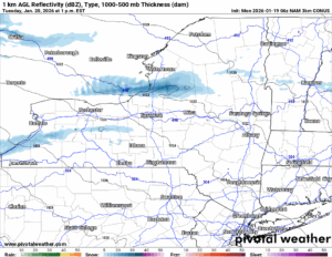
1 PM WEDNESDAY
4 PM WEDNESDAY
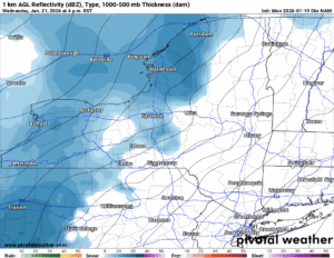
The next clipper system approaches during the day on Wednesday, especially in the afternoon and evening. That is is best chance for seeing additional snows across Upstate NY, not just in the lake effect areas. So if you have some accumulations put into the total, you do not see it tonight, and it’s sunny tomorrow, we did not blow it. Yet. One last round before the buzzer on this round of snow goes off at 7 PM on Wednesday 1/21/26.
THURSDAY AFTERNOON
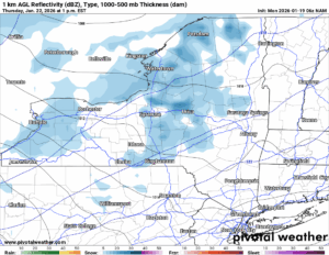
FRIDAY MORNING
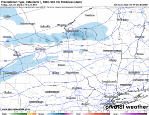
After this we have another storm system or clipper on Thursday. That one will actually bring the warmest temperatures we have seen in several days. Or will see over the next few weeks. Because after that, you don’t want to know where this is going to go! We are heading for the DEEP FREEZE!!!
6-10 DAY
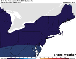
It has been quite a long time since we have seen the 80-90% BELOW NORMAL colors over THE ENTIRE NORTHEAST. Considering how this is the coldest time of the year, literally the coldest week. Let me scratch this out for you. And you may want to get by a fire or a heater for this one.
NORMAL HIGHS: 20s to 30
NORMAL LOWS: Single digits and teens
WHAT IT WILL BE:
HIGHS: Single digits and teens. Some days in the low 20s.
LOWS: Single digits to below zero. IN SOME DAYS, WAY BELOW ZERO! Multiple below zero days are a definite!
8-14 DAY
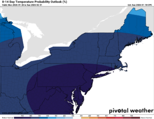
Looking to the end of January and to the first of February, NO CHANGE! If it wasn’t for the fact we had a January THAW in the first full week of the month, we could probably be going for a TOP 10 COLDEST JANUARY. But I think even with many of the bitter cold temperatures I am seeing in Canada now… I mean… It has been a GENERATION FOR ME, it has been since the early 2000s if not the 1990s that I have seen widespread 474 to 468 THICKNESS VALUES IN CANADA. You get that kind of air, that’s -40 to -60 type material. That type of air will challenge our state record low of -52 set in 1934 then tied again in 1979!
3-4 WEEK
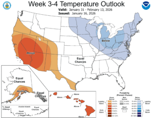
On the 3-4 week we see not a whole lot of improvement looking into the first two weeks of February. It continues warm in the west and cold in the east. Just like what has been talked about this winter. The big chill!
MONTHLY OUTLOOK FEBRUARY
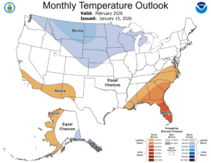
Now for all of February 2025, it is coming out near average. If it is supposed to be BELOW AVERAGE for the first half of February, what does that mean for the second half of February? It means temperatures by President’s Day, into that week when the kids are off could be spoiling. It could spike above normal. We could get melting. We may have issues then. Hopefully it will not be terrible then because it’s supposed to work out to normal. But just remember: We break 32 degrees for our average high on Valentine’s Day. And the temperatures steadily climb after that. Just beware.
I appreciate the fact you hung around this long to read up and catch up on the snowmobile season so far and the snowmobile season to come. Seriously the next 2-4 weeks look the best that they have been in over a decade. There is only one thing left to do: GET OUT AND ENJOY IT! At least wherever and whenever you can ride safely. Remember we don’t have a whole lot of the state snow covered and ready to ride. Yet. But we will soon enough.
NYSSA Public Trail Map
If you would like to advertise on the site, reach out anytime!
VENMO: @Zman291
CASH APP: #ZACKLUPIA
Zack and Rich Lupia
Upstate Snow
January 19, 2026
Please thank our advertisers on Upstate Snow!
Business Sponsorships
Ohio Ridge Riders
Enjem’s Flooring America
ilsnow.com
Saratoga Snowmobile Association
Southern Tug Hill Snow-Riders
Business Members
John Schoff Polaris Memorial Ride
Personal Members
Chris Schoff
Francis Miller
James Andre
Eric Vilovchik
Charles A. Klesse Sr.


