

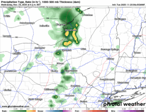
HERE IS OUR FIRST CALL FOR THE SNOW EVENT WHICH SHOULD BEGIN IN ABOUT 36 HOURS (FROM THE TIME OF WRITING – 7 AM TUESDAY 11/25) ACROSS WESTERN NY AND OVER THE LAKE ERIE REGION AND THE SOUTHTOWNS AND IMMEDIATE BUFFALO AREA. SEVERAL INCHES OF SNOW ARE EXPECTED HERE, INCLUDING IN THE CITY OF BUFFALO (PARTICULARLY THE SOUTHERN PART OF THE CITY). LESSER AMOUNTS TOWARDS THE TONOWANDAS AND THE NORTH TOWNS. ROCHESTER AREA SHOULD BE A GENERAL 2-4 WITH LOCALLY HIGHER AMOUNTS. SYRACUSE WILL BE A 4 TO 8 WITH LESS NORTH AND WEST, AND MORE SOUTH AND EAST. UTICA WILL BE A 4 TO 8 AS WELL WITH MORE BOTH NORTH AND SOUTH. THE WINNERS HERE WILL BE THE TUG HILL, ADIRONDACKS AND HILLS SOUTH AND EAST OF SYRACUSE WHERE OVER 8 INCHES OF SNOW, LOCALLY 16 INCHES OR MORE COULD FALL IN THE 36 TO 84 HOUR FORECAST PERIOD.
Whoa that’s a mouthful to get out! And the sun is not even up yet! We wanted to make sure you folks, the majority of which are traveling today and or tomorrow have the best set of weather information to factor into your plans for on the way to turkey, as you fall asleep after it, or shop till you drop on Friday being chased by these lake effect squalls!

BEFORE THIS
60 degrees! If not even higher! Is it a record high? Nope. But it is a lot closer to a record high that you would like to be getting into the time of year we are now. On Wednesday Afternoon, our sharp cold front moves on through, the winds turn to the WSW, begin to whip up (20-40 MPH with higher gusts), and the lake effect snow begins not long after the front has cleared the area. Just because that is how sharp the cold air is.
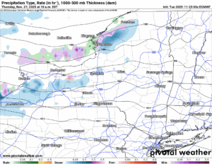
THANKSGIVING DAY
Here the worst of the snows are playing with the Watertown and Buffalo areas. We are zeroing in on a 250 to 260 wind direction as of right now, which should leave the worst of the snows just south of those cities. If you are in areas just to the south of Watertown or Buffalo, GET READY! You will have significant snows and significant issues to deal with. At this point in time that is almost a guarantee!
THANKSGIVING NIGHT
Our reinforcing shot of colder air begins to work on in. This changes the flow from 250-260, to more of a 270 flow. It will not be like this for long. You notice the snowfall amounts are not amazingly high compared to other events. That’s the reason why. This event will keep moving.

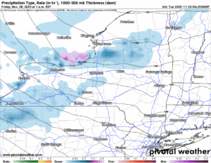
BLACK FRIDAY AM
As the reinforcing trough moves out, the winds shift to the WNW, bringing the snows well south of Buffalo and into the Southern Tier off of Lake Erie. For Western NY, particularly the Buffalo area, Thanksgiving Day is your big snow day. For those off of Lake Ontario, it’s our turn now! With the winds now coming south of the Tug Hill, this is when the Southern Adirondacks, Mohawk Valley and the northern suburbs of Syracuse get the best shot of snows with an inch per hour likely. Even though this will probably last only a few hours and most of your accumulation is likely within this range.
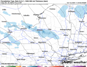
BLACK FRIDAY PM – FRIDAY NIGHT
The flow goes more to the NORTHWEST. This brings the heaviest snows to the Syracuse area, the hills south and east of Syracuse and into portions of the Southern Tier. It will hang on just a few more hours here, and in fact, may redevelop for a time Friday Night before this system dies out by daybreak on Saturday. By then, this whole system is OVER!
SNOWFALL ACCUMULATIONS
Most of the snows in the Watertown and Buffalo areas, Northern NY, will hit Wednesday Night through Thursday Night. Most of the snows in the South Towns of Buffalo, The Tug Hill and the Central Adirondacks, will hit on Thanksgiving Day and into the night of Thanksgiving. In the Southern Adirondacks and Mohawk Valley, from Thursday Night through Friday Morning. In the Syracuse area, hills south and east of there, and south of the Thruway into the Southern Tier and the Catskills, Black Friday is your day.

AFTER THAT
The next storm was looking like a solid almost slam dunk warm air advection precipitation scenario. Not anymore. Because the low is winding up more in the Great Lakes, more of the precipitation will be heading that way closer to the Great Lakes and not closer to Upstate NY. Even so we do get hit with snows on Sunday. We certainly cannot rule out a quick 1 to 3 inches before it goes to rain. We are now getting to the time of year for the next four months, you can call this on most systems that go by. What about the bigger ones? The ones with more impact? This is what we are prepared for!
If you would like to advertise on the site, reach out anytime!
VENMO: @Zman291
CASH APP: #ZACKLUPIA
Zack and Rich Lupia
Upstate Snow
November 25, 2025
Please thank our advertisers on Upstate Snow!
Business Sponsorships
Ohio Ridge Riders
Enjem’s Flooring America
ilsnow.com
Saratoga Snowmobile Association
Southern Tug Hill Snow-Riders
Business Members
John Schoff Polaris Memorial Ride
Personal Members
James Andre
Eric Vilovchik
Charles A. Klesse Sr.


