
This Morning Blog is brought to you by the Town of Webb! Featuring SNOWDEO this upcoming Friday, Saturday and Sunday! The 48th Annual SNODEO, sponsored and held by the Central Adirondack Association, is the “kick-off” weekend for the 2025/2026 snowmobile season. With major snowmobile manufacturers, a Vintage Snowmobile Show, and Snowmobile Raffle, there is something for everyone! You can check out Old Forge Camping Resort or Waters Edge Inn for more information!
Good Morning Upstate Snow Nation! Welcome to DAY 1 of my 2025-26 season, which I expect to be, the best ever! It certainly looks like we are starting off the strongest in at least 25 years! Not since 2000 has a December started this cold! And with many below zero nights, even memories of 1989 are creeping in. We won’t go THAT far or THAT cold, but lets just say: I don’t expect ANYTHING will ever beat December 1989!

BITTER COLD NOW
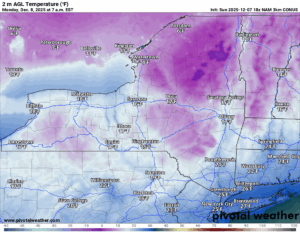
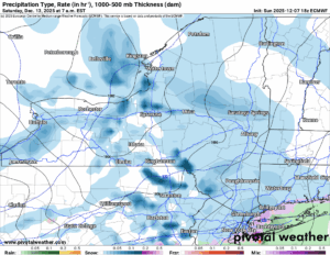
It’s breezy and borderline brutally cold again across Upstate NY after the storm system that dumped a few inches of snow, particularly yesterday (GO BILLS!!!), hit the state. And Orchard Park. Thank you very much! Temperatures are on the cold side today with highs only in the teens to lower 20’s across Upstate NY with warmer locations down south and east.
COLD AGAIN TONIGHT
Tonight will be cold again. It will not be this cold again until this next weekend’s super cold blast coming up. More on that in a minute. Just wanted you to look after the zero to MINUS 10 air that will be over the riding areas of NY. Yikes!
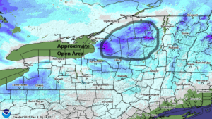
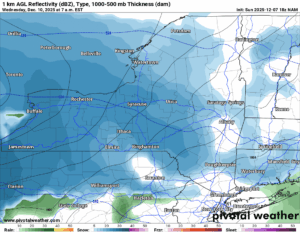
TUESDAY SYSTEM
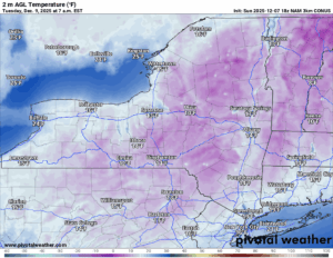
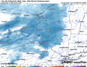
The next storm rolls in quickly with snow developing Tuesday afternoon and especially by Tuesday Night. It starts off cold enough for snow, but it does not stay like that for long. This storm will be a quick hitter with a few inches likely in spots.
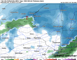
WEDNESDAY SYSTEM
The warm front will lift over the state heading into Wednesday, which will bring thermometers above freezing, especially in the lower elevations. In many lower elevation cities like Albany, Kingston, Syracuse and Rochester, I would expect 40 degrees or better on Wednesday. This means it becomes RAIN. This also means all that snow on the ground so far begins to melt and compact. I am expecting some snow loss across the state but no big WIPEOUT of snow. At least not this time.
NEXT COLD BLAST LOOMS
It starts on Friday. Snow showers and lake effect squalls develop, then last into the weekend. There is the possibility of additional lake effect snows with several inches possible. Because we are talking day 5+ here, we will not put accumulations on this yet. Another big shot of arctic air comes pouring on down, this is by far the biggest one of the season and potentially the biggest one in the last few years. It does look like most of this comes into the Great Lakes, the Ohio Valley and the Southeastern US. It looks like the worst of this blast may miss the Northeast and Upstate NY. It will still be plenty cold though.
BOTTOM LINE
Tomorrow we release snowfall maps through Wednesday Night.
Wednesday we release snowfall maps through Thursday Night.
Thursday we release snowfall maps through Friday Night.
Friday we release snowfall through Sunday Night (THE WEEKEND)
Given how much snow and how much cold we have been seeing, if anything, it has been difficult coming up with when and how to put out these forecasts. We don’t want to put these out too far. Also don’t want to put these out last minute. Please forgive us as we navigate this winter as best as we can.
If you would like to advertise on the site, reach out anytime!
VENMO: @Zman291
CASH APP: #ZACKLUPIA
Zack and Rich Lupia
Upstate Snow
December 8, 2025
Please thank our advertisers on Upstate Snow!
Business Sponsorships
Ohio Ridge Riders
Enjem’s Flooring America
ilsnow.com
Saratoga Snowmobile Association
Southern Tug Hill Snow-Riders
Business Members
John Schoff Polaris Memorial Ride


