
This Morning Blog is brought to you by D.R.A.G. of Speculator that has a hard working group of volunteer club members, work with local and state governments, to maintain and groom over 25 miles of Snowmobile trails in the Speculator and Lake Pleasant region. Our commitment to grooming and maintenance helps make the trail system more enjoyable and safe to use. We help make local business more accessible with our Business Access Trail as well as provide a well-groomed connection between surrounding towns and other trail systems. To please click here.
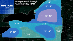
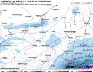
The heaviest snows are in Northern NY and into the Capital Region and Hudson Valley. It’s not over in Central NY and Western NY but there are breaks in the precipitation. Here the warmer air is rolling on in with temperatures surging through the 30s and in the lower elevations, making it into the lower 40s. It will definitely lead to some melting and compaction of the snow in some areas. I believe that will be where most of the snow is not. Except for areas south of Buffalo where 40 or better will do some damage to the lake effect being around at least 3-6 hours.
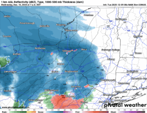
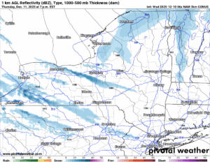
7 PM TONIGHT
Our powerful low is moving into Northern NY and will be heading for Northern New England next. A secondary cold front, ushering in the much colder air following this rain/mix/snow event today, will change it all back to all snow in all locations quickly in the evening. Expect some accumulations overnight. Here is the bottom line: If you end up with little to nothing through this evening, DO NOT CONTACT ME TO COMPLAIN! This forecast is through 7 AM on THURSDAY MORNING. And this is also when I will count on any snow I fall short on, to come back to the fold here.
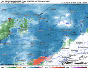
7 AM THURSDAY MORNING
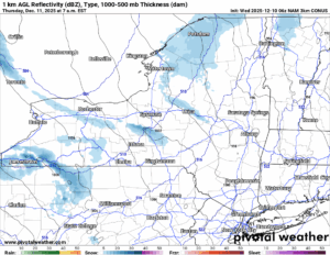
The general large areas of snow have gradually disappeared and have been replaced with snow showers coming off of Lake Erie and particularly Lake Ontario with a few heavier squalls being involved. It has turned much colder behind the storm and it will be a much colder day Thursday as opposed to tomorrow. Just warning you now. In areas that continue to get snow, expect more accumulations.
You have more snow showers with areas of heavier lake effect snow coming in. The lake effect will continue into Friday as well but it will become very localized with minimal additional accumulations after sunrise on Friday morning. For most of the state, Friday should be an OK day.
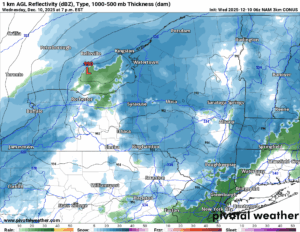
7 AM SATURDAY
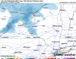

Our next system rolls in on Saturday morning, a clipper, with our next chance of snow showers. There will be some lake effect in back of this, however, nothing as crazy as like today.
7 AM SUNDAY
More scattered snow showers with some lake effect thrown into the mix. Sunday will not be a HUGE day when it comes to the snow. It will be a HUGE day when it comes to the COLD! We have this weekend, JUST IN TIME FOR SNOWDEO FRIDAY, SATURDAY AND SUNDAY, SOME MORE BELOW NORMAL COLD! Do you like single digits and below zero up in the Adirondacks in early December? NOW IS YOUR CHANCE TO ENJOY IT!
8-14 DAY OUTLOOK
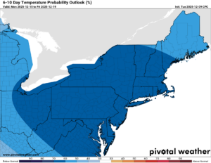
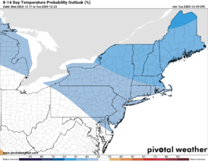 Well at least we know the cold will not be going anywhere anytime soon. For the next 10 days at least. As we get closer to the week of Christmas, there is a possibility. Nothing like a Christmas Day Massacre of 2020. No way on that!!!
NYSSA Public Trail Map
If you would like to advertise on the site, reach out anytime!
VENMO: @Zman291
CASH APP: #ZACKLUPIA
Zack and Rich Lupia
Upstate Snow
December 10, 2025
Please thank our advertisers on Upstate Snow!
Business Sponsorships
Ohio Ridge Riders
Enjem’s Flooring America
ilsnow.com
Saratoga Snowmobile Association
Southern Tug Hill Snow-Riders
Business Members
John Schoff Polaris Memorial Ride
Personal Members
James Andre
Eric Vilovchik
Charles A. Klesse Sr.


