
The Morning Blog is brough to you by the Inlet Barnstormers Snowmobile Club. The club has been around since 1998 and has dozens of miles of high quality trails for all of Upstate NY to enjoy! One club decal is mailed along with your membership voucher and other materials when you join our club or renew your membership. And also: CO-SPONSORS OF SNOWDEO WITH THE RIDES COMING TOMORROW! AND IT WILL BE COLD WITH THE THREAT OF SNOW!
IT IS TIME TO MEASURE UP! NOW REALISTICALLY, THIS IS DONE AND RECORDED EVERY 6 HOURS. I AM ASKING YOU TO MAKE A MEASUREMENT TOTAL OF WHAT FELL OVER THE LAST 24 TO 36+ HOURS. I AM SORRY. IF ANYTHING THESE WILL BE A LITTLE BIT LOWER. IT IS WHAT IT IS.

Where I believe my forecast was most wrong? Central and Northern Adirondacks. Went too high too far north with the heavier snows. Nailed the bullseye on the heavy snows to the south, the lower totals in the Mohawk Valley and the higher totals in the hills to the south. Most of the state was OK… but not all of it. Always get some parts of Upstate NY wrong on every snowfall map I do. This time it happened to be the Central and Northern Adirondacks.
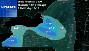
Here is what is to come over the next 36 hours. Our snowfall as clipper systems and more synoptic systems is over. The localized bands of intense lake effect squalls otherwise nothing a few miles down the road… is our normal again.
1 PM TODAY
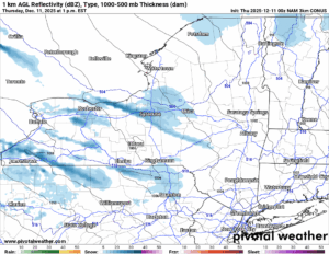
Snow showers with the heaviest lake effect squalls will be confined into Wayne County, through the Syracuse area, then points south and east of there. South and east of Buffalo we also have an area of snow showers with heavier lake effect. Several inches of snow expected here too.
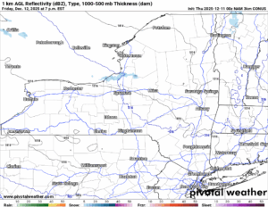
7 PM TODAY
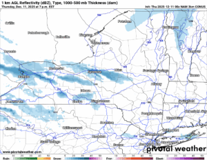
As the evening wears on we will see these bands lift towards the north and then weaken. Snow showers and squalls will become less and less of a factor overnight. Driving in the morning on Friday should be fine for most areas.
7 PM TOMORROW
Then we catch a break Friday Night and into Saturday. At least for part of the day. Until our next storm moves in. This one will be another clipper, followed by lake effect, followed by yet another temperature drop.
4 PM SATURDAY
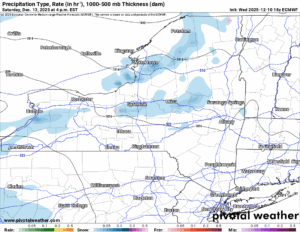
The clipper is not showing up the best on the Euro or NAM at this point. But we know that it is there. And we know at least another few inches of snow is a likelihood.
7 AM SUNDAY
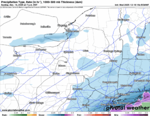
Here is what it looks like as our clipper is transitioning into a Nor’easter on its way off the coast with lake effect developing behind it. Again. With very cold air to support it.
10 PM MONDAY
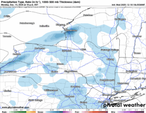
More snow showers and lake effect snow will be around late Monday and going into early Tuesday. IS THIS PATTERN EVER GOING TO END? WE HAVE SEEMINGLY BEEN IN WINTER FOR FOUR TO SIX WEEKS ALREADY! AND THE PATTERN HAS JUST STARTED! Is there any hope for getting off of this record cold and snowy place we are on?
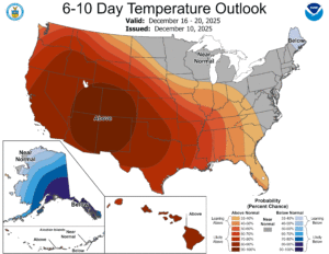
6-10 DAY
8-14 DAY
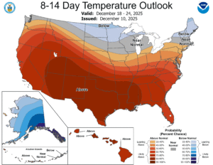
WHY YES! YES THERE IS HOPE! Even in the 8-14 it still has slightly below normal temperatures over Northern NY, which is the only part of NY you may ride until January 2nd ANYWAY. However, this Christmas Week Warmup and looking ahead to that week between Christmas and New Years looking warmer each day: THAT IS NOT GOOD. THAT IS NOT SITTING WELL WITH ME. Even though averages are down to freezing (and in the 20s up north), the growing possibility of a pattern change and a warming trend is never a good sign. Especially around the holidays. And after all the bitter cold we have had to deal with, not even being able to break a Top 10 coldest December after all this would be a very painful thing. It has been 73 months since the last Top 10 coldest month. November 2019. It is the longest streak ever in our history going back to 1893 in our weather records here in Rome. That is not good. Let us hope we have room left!
NYSSA Public Trail Map
If you would like to advertise on the site, reach out anytime!
VENMO: @Zman291
CASH APP: #ZACKLUPIA
Zack and Rich Lupia
Upstate Snow
December 11, 2025
Please thank our advertisers on Upstate Snow!
Business Sponsorships
Ohio Ridge Riders
Enjem’s Flooring America
ilsnow.com
Saratoga Snowmobile Association
Southern Tug Hill Snow-Riders
Business Members
John Schoff Polaris Memorial Ride
Personal Members
James Andre
Eric Vilovchik
Charles A. Klesse Sr.


