
The Morning Blog is brought to you by BARNES CORNERS SNO-PALS! We maintain and groom 100 miles of snowmobile trails, located in Jefferson and Lewis Counties of upstate New York, on the famous Tug Hill Plateau! For more information on joining our club CLICK HERE.
Good Morning! Today is SNOWDEO DAY 1 and today is DAY 5 of our early season riding! Not since 2018 have we had this opportunity at all. Not since the 2000s have we had the chance with this much snow and this much cold. If you are heading to Old Forge today or anytime this weekend, RIDE SAFE, RIDE RIGHT, RIDE SLOW, AND JUST ENJOY THE AMAZING TIME THAT EVERYONE UP THERE WANTS TO PUT ON FOR YOU!

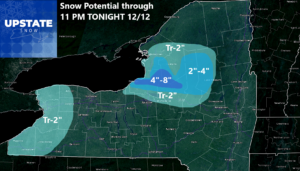
1 PM TODAY
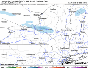
We have more lake effect snow, best chance of which will fall across Oswego and Northern Oneida Counties. It may extend further north and east, but this is our area of focus for now. Locally several inches of additional snow is possible.
7 PM TONIGHT
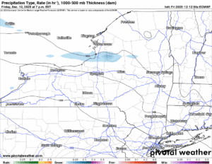
By this point I would expect the snows to finally be tapering off. For Friday Night? It should actually be a chilly night without much going on across Upstate NY. We need this break. There is more coming.
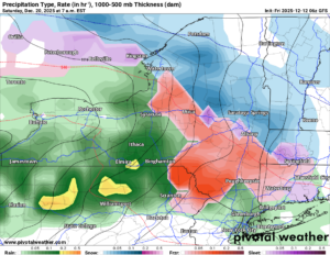
1 PM SATURDAY
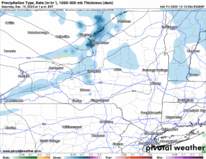
Our next storm rolls on in, a clipper, this one should be a light one. Expect a few inches of snow with this tomorrow afternoon into tomorrow night before this system screams out of here as fast as it got in here.
7 AM SUNDAY
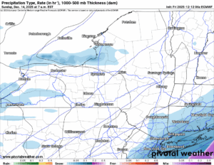
This is another LAKE EFFECT SNOW DAY! Winter Storm Watches and Warnings are already up across most of Western NY, and from Wayne County all the way to the Watertown area, Lewis County, and Oswego County. If anything I would expect Albany and/or Burlington to extend these watches and warnings further into their zones as we approach this lake effect setup. It is not the best that I have seen. It is definitely not the worst either. Plenty of cold air. Expect this stuff to wind down by Sunday Night and into Monday Morning.
7 PM MONDAY NIGHT
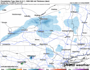
Because our NEXT CIPPER comes on in right after the lake effect event on Sunday! Is it EVER going to stop snowing? Is it every going to get to a point we have a few days just to NOT SHOVEL, especially where there is LAKE EFFECT?
7 PM SATURDAY 12/20
This is about a far out as we will go with maps. Unfortunately it does show finally what everyone has been praying for, for weeks now. A BREAK IN THE SNOW! That is the good news. The bad news: It comes in the form of RAIN. WARMER AIR FLOODS ON IN. TEMPERATURES RISE. RAIN FALLS. SNOW MELTS. Now don’t worry, some parts of the state particularly the northern parts where we can snowmobile are better than south and west. Plus this is 8 days away. PLENTY OF TIME TO FIGURE THIS OUT. DO NOT TAKE THIS AS GOSPEL. YET AT LEAST. We have built up a very healthy early season snowpack, one of the best and earliest we have in decades! Certainly since the start of this show. It will take a lot of warmth and flooding rains to wipe out all of the early season gains over the last month, but just be on notice: THE CHANGE IS COMING!
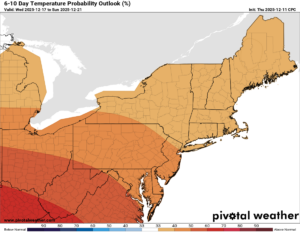
6-10 DAY
8-14 DAY
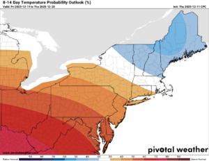
If anything, it does look slightly better, especially for Northern NY as we approach the week of Christmas. We still cannot go into specifics on storms, especially on timing and events, but I can tell you 30s by day, teens by night, that will do a lot more to hold snowpack around then a BLOWTORCH pattern. That has been said and feared around the last few days. Please don’t but into it lock, stock, and barrel. Yet. We still have time. This is NOT the look of a BLOWTORCH.
NYSSA Public Trail Map
If you would like to advertise on the site, reach out anytime!
VENMO: @Zman291
CASH APP: #ZACKLUPIA
Zack and Rich Lupia
Upstate Snow
December 12, 2025
Please thank our advertisers on Upstate Snow!
Business Sponsorships
Ohio Ridge Riders
Enjem’s Flooring America
ilsnow.com
Saratoga Snowmobile Association
Southern Tug Hill Snow-Riders
Business Members
John Schoff Polaris Memorial Ride
Personal Members
James Andre
Eric Vilovchik
Charles A. Klesse Sr.


