
The Morning Blog is brought to you by the Indian Lake Snowarriors! Being a Snowarrior gives you a part in a very socially active club that is involved in the Indian Lake Community 365 days a year. Come and help out on the trail or equipment maintenance events, be a part of our 4th of July Parade Float or our Snocade Week activities, help with our community outreach during Moose Festival or the Black Fly Challenge. Join us for a group ride to visit the WW Durant, have your children obtain their Youth Snowmobile Safety Certification, get certified to run our Groomer and learn how. For more information on becoming a Snowarrior, CLICK HERE
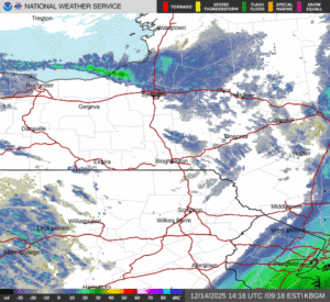
WHAT IS GOING ON AT 9 AM?
We have various areas of snow showers and lake effect squalls. Off of Lake Ontario, they are sinking south though Oswego County towards Cayuga, Onondaga and Wayne Counties. They are also off to the west of Rochester as well. Off of Lake Erie, as you know, south of Buffalo, mainly Chautauqua and Cattaraugus Counties. To the east it is quiet over most of the rest of the state. With the exception of the Hudson Valley and south where there is light snow with our developing storm offshore. In the New York City area and into Long Island, steady snows with a general 3 to 6 inches of accumulation are expected there in total by this evening.

7 PM THIS EVENING
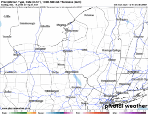
It will become at least partly cloudy if not mostly clear across the state tonight. Temperatures will be heading for the basement again with some north country areas getting below zero. Again!
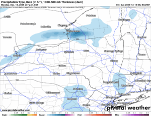
7 PM MONDAY
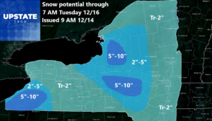
It clouds up quickly tomorrow with afternoon snow showers. There may be a quick squall in this as well. Then the focus turns to lake effect. Again. Off of Lake Ontario. Again. The focus is only for a short time as believe it or not: The cold air supply is actually limited this time. So after about 12 hours of this mess, and these additional accumulations, we can FINALLY take a break for accumulations maps for at least most of the rest of the week.
Tuesday and Wednesday expect to see a mix of clouds with some sunshine. Don’t expect full dark overcast all the time. Don’t expect bright blue skies either. Do expect temperatures to moderate with it getting above freezing on Wednesday and some folks taking a shot at 40. That definitely happens on Thursday along with an increase in clouds. Highs getting into the 40s across the state. This means snow melting and compacting will begin. For most of the state this is just a temporary thing. But watch out!
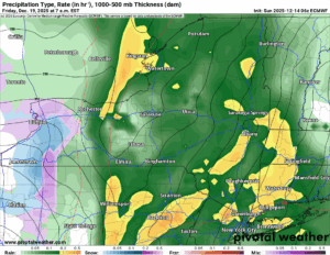
7 AM FRIDAY
Thursday Night the rains come pouring into the state, and this is all over the state come Friday Morning. Oh my. This will definitely have the snowpack take a hit. Only in areas with the pack less that 10 inches, or in particular less than 6 would I be the most worried about it, but even where there is feet of snow, it will have an absolute impact. Since we are now 5 days away from it, it’s time to start getting ready for it.
7 PM FRIDAY
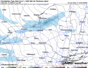
By Friday Night all of Upstate NY is swirled back into the cold, the snow, the lake effect! It’s back! There will definitely be a hit on the snowpack on Friday the 19th, however, we will see what happens from there. It is looking like our temperatures go back to near normal this weekend which means (now) near freezing during the day and well below freezing at night. Like teens.
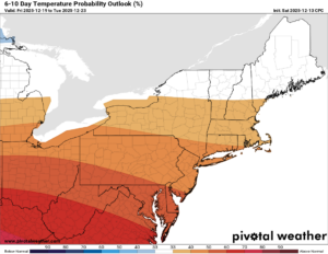
6-10 DAY
8-14 DAY
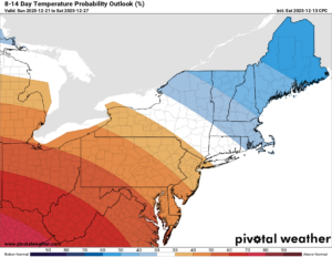
We have a battle zone shaping up going into the week of Christmas. And even until New Years. Just to our north: Brutal cold! Just to our south: It will be warm with 50s and 60s abundant! Where will Upstate NY fall into this???
I don’t know. Yet.
Will it be a White Christmas? I don’t know. Yet. All I know is the rains on the 19th will play a major role in who gets a White Christmas and who does not. All I know is this: Play the percentages with that storm.
NYSSA Public Trail Map
If you would like to advertise on the site, reach out anytime!
VENMO: @Zman291
CASH APP: #ZACKLUPIA
Zack and Rich Lupia
Upstate Snow
December 14, 2025
Please thank our advertisers on Upstate Snow!
Business Sponsorships
Ohio Ridge Riders
Enjem’s Flooring America
ilsnow.com
Saratoga Snowmobile Association
Southern Tug Hill Snow-Riders
Business Members
John Schoff Polaris Memorial Ride
Personal Members
James Andre
Eric Vilovchik
Charles A. Klesse Sr.


