
The Morning Blog is brought to you by the Salisbury Ridge Runners! “Where old friends meet!” The Salisbury club is simply, the largest club in the entire state of New York! Today, we have 116 plus miles of well maintained trails, an extensive fleet of grooming machines and a very capable volunteer staff of workers. Our club offers a full modern clubhouse facility. We have land holdings of 100+ acres, a grass and snow racetrack, the largest Poker Run in the area and a legal gambling license. Nearly everything you would want or asking from a club, Salisbury has got! For more information CLICK HERE!
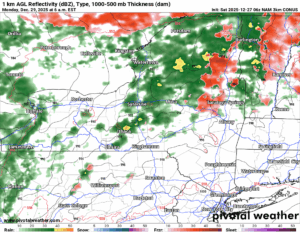
POST MORTEM ON LAST NIGHT
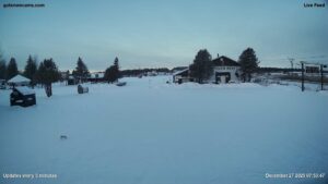
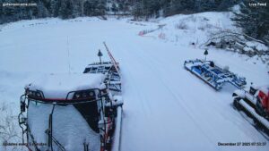
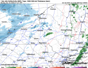
That was a tough night wasn’t it? The snow came in hard and heavy! Many areas saw 1 to 2 inches of snow per hour during the evening commute or to/from Friday Night Dinner. That never works well! A majority of areas is Central NY, eastbound (basically I-81 to the east) received 4 to 8 inches, some got more, a few got less, but most got around that. Lesser amounts across the Finger Lakes and Western NY where also the snow pack is not good. More on that in a minute. Across the rest of Central and Eastern NY, the snowpacks are a lot more healthy and areas that can ride over the holiday season are for the most part riding and doing well! Not every single trail is in great shape. The inner woods trails are still rough. Don’t even ask about the lakes. But for this weekend, if you want to ride, you have many good options for today, tonight and tomorrow. Salisbury is one of them! Most locations that are open in the Tug Hill and Adirondacks are GOOD!

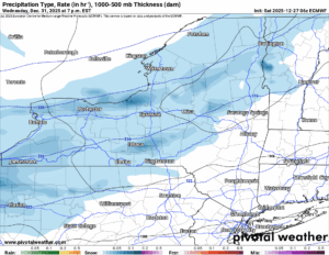
TOMORROW NIGHT’S STORM
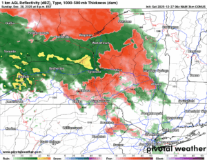
This one coming in is a warm storm. This will pass well to the north and west of Upstate NY. Unlike the last storm which rolled on through with 4-8 of pow pow mostly, this one is coming from the south and the west. Record warmth is out ahead of this storm, so this means you will not see snow in this scenario. FREEZING RAIN AND SLEET are your enemies this time. Then a pouring down heavy rain on Monday before the cold front gets here then turns the rain back to snow in the afternoon and into the evening on Monday as the storm pulls away.
RING IN THE NEW YEAR WITH SNOW AND LAKE EFFECT
Starting Tuesday then going through the New Year, all the way to basically as far as we can see reasonably which would be around January 2-3, expect periods of snow with locally heavy lake effect snows across areas downwind of Lake Ontario and Lake Erie. For areas west of I-81, you will be simply starting over after this rain storm on Monday. Seriously you will. For areas east of I-81, especially north of I-90, you will get hit but not as bad plus you will have ice on top of the snow pack that will help to slow melting. I would expect many areas east of I-81 and especially north of I-90 to survive this.
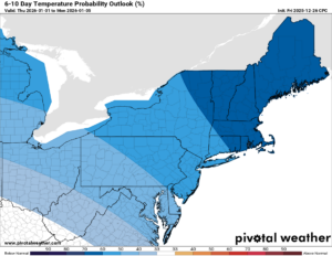
6-10 DAY
BELOW NORMAL! That’s about all I can say is that through the first weekend in January it will be snowy and COLD! Not record cold but you get where I am getting at. Not much above freezing. At all. But don’t worry. At 8-14 days it will gradually return back to normal. But remember in January, NORMAL IS STILL GOOD FOR SNOW. Most of the time.
Stay tuned! I will have more details on this event tomorrow.
NYSSA Public Trail Map
If you would like to advertise on the site, reach out anytime!
VENMO: @Zman291
CASH APP: #ZACKLUPIA
Zack and Rich Lupia
Upstate Snow
December 27, 2025
Please thank our advertisers on Upstate Snow!
Business Sponsorships
Ohio Ridge Riders
Enjem’s Flooring America
ilsnow.com
Saratoga Snowmobile Association
Southern Tug Hill Snow-Riders
Business Members
John Schoff Polaris Memorial Ride
Personal Members
Francis Miller
James Andre
Eric Vilovchik
Charles A. Klesse Sr.


